

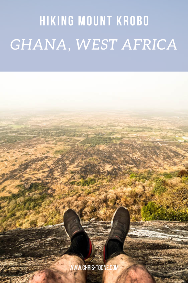
Hiking Mount Krobo, Ghana: Everything You Need to Know
Within a week of regularly driving the Tema-Akosombo road, it was clear that one mountain towered above the rest: cue Mount Krobo. After weeks of trying to arrange a hike the plans finally panned out. Here’s everything you need to know for a great half-day adventure…
Please note: all info below is accurate as of January 2023
Having been to Ghana on and off for the past decade, my trips were isolated to the same stretch of road between Accra, Kumasi, and Berekum leaving the Eastern Region of the country an untouched landscape full of adventure.
Within a week of regularly driving the Tema-Akosombo road, it was clear that one mountain towered above the rest: cue Mount Krobo. After weeks of trying to arrange a hike the plans finally panned out.
Here’s everything you need to know for a great half-day adventure!
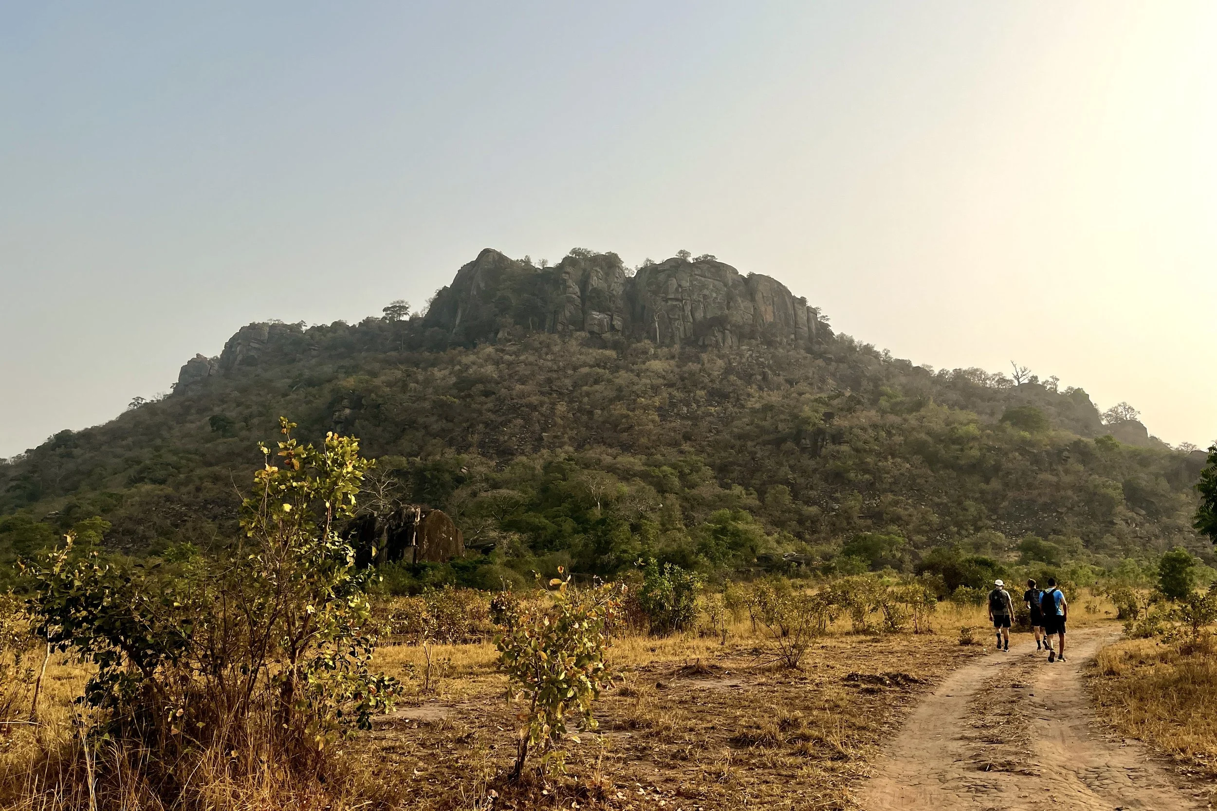
Hiking the base of Mount Krobo, Ghana
A BRIEF HISTORY OF MOUNT KROBO
Dating back to the 16th century, the Dangme people of East Africa up and left their settlements, deciding to migrate towards present day Ghana. Once they reached West Africa, the group made friends with other ethnicities as they passed through, including the Ewe people.
As the trek progressed, a split from the Ewe became necessary and it was at this point in their journey that the Krobo refer to as Lorlorvor, meaning “love has ended.”
The Krobo people crossed the Volta River in continued search of a new settlement when they found themselves surrounded by the Akan and Guan ethnic groups. Fear of these perceived threats forced them to climb an isolated mountain on the plains near the river, known today as Mount Krobo.
Having experienced first-hand the difficult climb as a natural safety measure they began to establish their new settlement, quickly erecting multi-story homes and irrigation systems.
As the Krobo population continued to expand, the colonial government found it increasingly difficult to monitor and control the settlement. As a result in 1892, the British rulers gave the community 3 days to leave the mountain. The people fled with as much as they could carry and what was left behind was destroyed.
To this day, the Krobos continue to organize a pilgrimage to pay homage to their ancestors.
GETTING THERE
Not the most conveniently located attraction in Ghana, the easiest way to access Mount Krobo is by taking a tro-tro or taxi to Akuse Junction. From here, the unmarked trailhead is 3.1km south on the left side of the road, just past Kings and Queens Teaching Hospital.
Although possible to walk from the intersection, it’s not advisable given the volume of speeding traffic along the Tema-Akosombo Road.
If all else fails, the trailhead is pinned below, and the path can be seen from Google satellite images.
WHEN TO GO
For sweeping views across the plains, it’s best to avoid the Harmattan season which runs from November to March as the horizon is often laden with dust that obscures the landscape.
HELPFUL INFO
Some reports indicate a 7.50 GHC entrance fee to a local farmer, but we did not encounter anyone. It’s also vital to bring plenty of water and sunscreen as the mountain is exposed most of the ascent.
Other things to consider:
A reliable and comfy day pack
Pack snacks or buy fruit from the stands at Akuse Junction
Wear shoes with plenty of tread
Wear long, lightweight pants
Bring bug spray
Plan for 4 hours, round trip
Walking poles
Start early in the morning to avoid the hottest part of the day
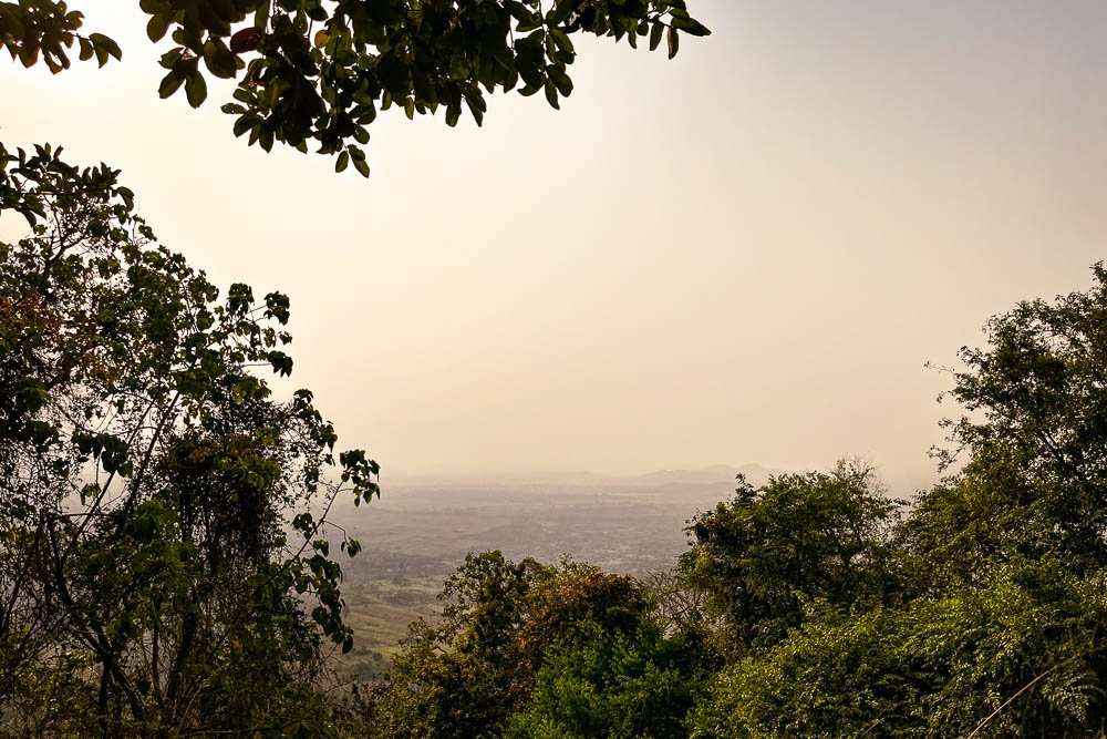
A glimpse of the landscape from the top of Mount Krobo, Ghana
WHAT TO EXPECT
Once turning off the Tema-Akosombo Road, the hike starts flat as the dirt path winds through the brush and approaches the eastern face of the mountain. The tree-lined trail concludes at a clearing with a shelter, washrooms, and a beautiful baobab tree.
From here, the trek begins to quickly ascend through the trees. Remember to pace yourself and stay hydrated – it’s not a race to the top. Take advantage of the many lookouts along the way for some well-deserved rest.
On this particular day, the brush had just been burned along the trail, so the breaks were a welcomed reprieve from breathing in the Harmattan dust and ashy air.
Eventually, the path opens up to ruins from the Krobo civilization that once dwelled on the mountain. We wandered around the old foundations of houses while uncovering clay pots that had slowly been reclaimed by the Earth.

Ruins of the Krobo settlement
At this point, it is not much farther to the first vista that looks west over the plains. Once you have had a chance to take in the sweeping landscape, continue walking north along the top of the mountain to reach the trail's end, marked by a metal cross.
Relax, refuel, and enjoy the views.
The easiest and safest thing to do is treat Mount Krobo as an out-and-back trail. There is no loop however a local Ghanaian we met at the peak insisted we try the “shortcut” down. This included descending a solid rock wall into a ravine and galloping down the western face of the mountain that we had previously labeled “too steep to climb” as we reached the trailhead from the main road that morning.
Truth be told we would never have found this path without a guide, so best to descend back through the Krobo ruins.
IMPORTANT NOTES
Here’s what I wish we would’ve done differently:
Pin the location of the trailhead and have the taxi stop at the mark. We got out too early at Akuse Junction and had to walk the 3.1km down the Tema-Akosombo road
Bring hiking shoes. I used runners and immediately regretted my decision as we started the steep descent through the ashy brush
Wear long pants. The trail is clearly defined, but that doesn’t mean brush doesn’t get in the way. I left the mountain with scrapes and cuts up and down my legs. Nothing serious, but next time I’ll pack pants
Get the taxi driver’s phone number to call on the descent and meet at the end of the trailhead to avoid walking back to Akuse Junction for a ride

Views from the top of Mount Krobo, Ghana
All in all, it made for a great morning adventure. Be sure to do a little digging on the Krobo people before the hike. Knowing the history of the mountain made the experience meaningful beyond the beautiful fauna and striking landscape.
Have you hiked Mount Krobo before or know of other adventures you want me to experience in Ghana? Leave a comment below and let’s keep exploring!
As always, thanks for reading & happy travels.
Sharing is caring! Pin this post for later.


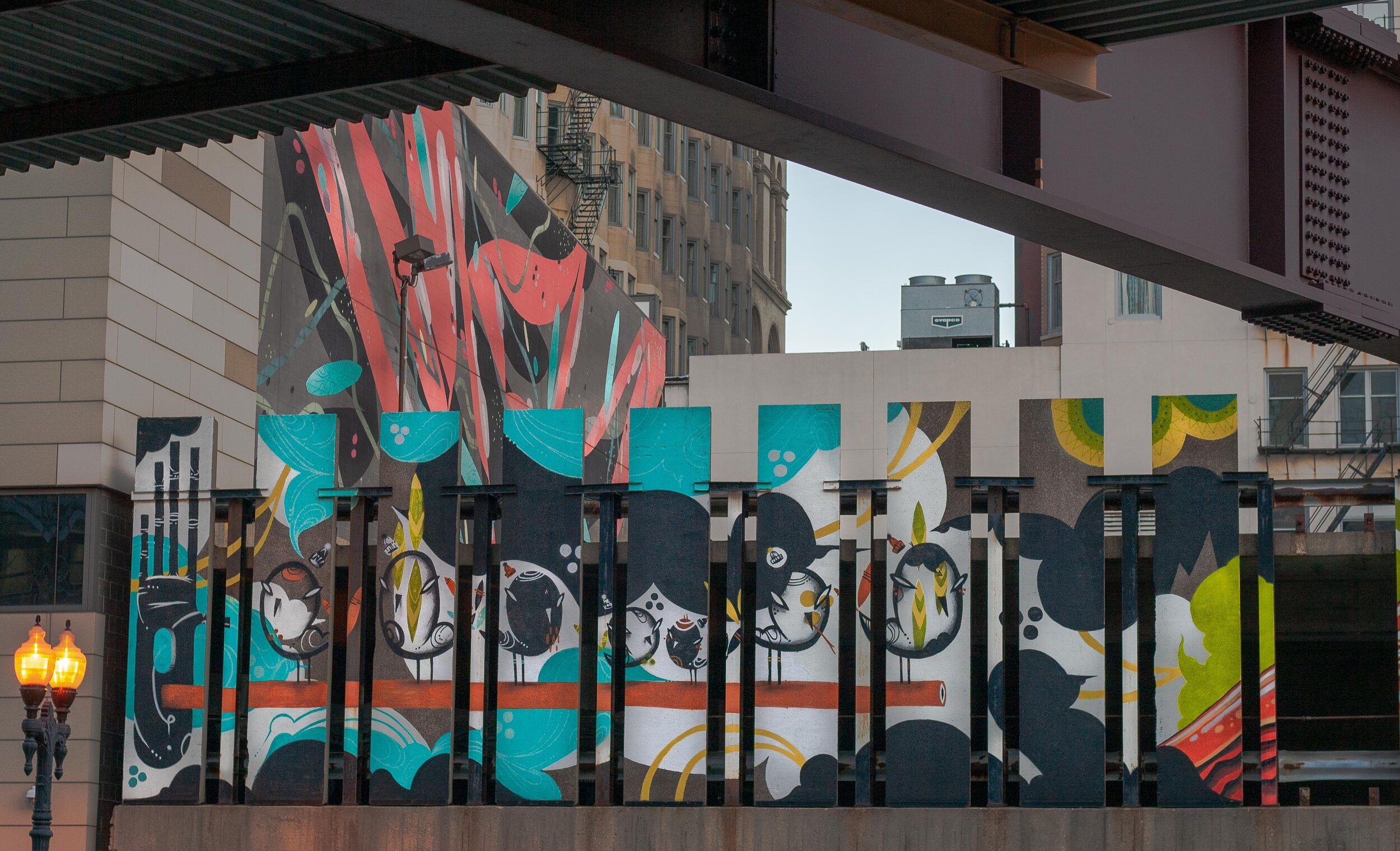
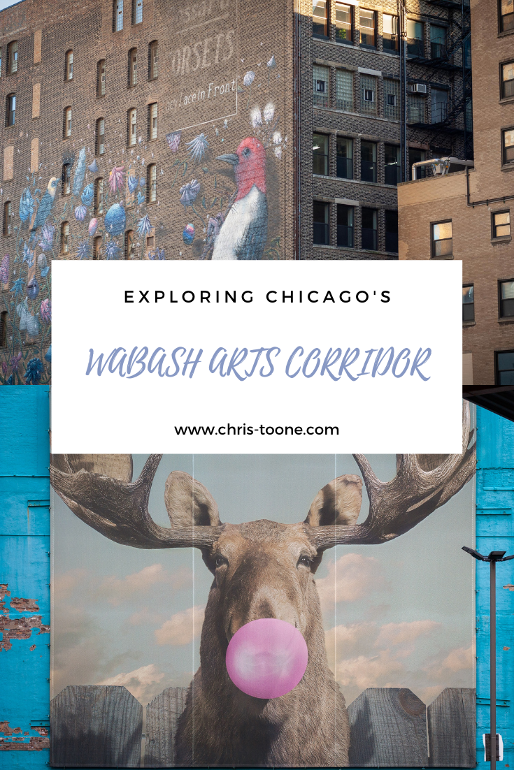
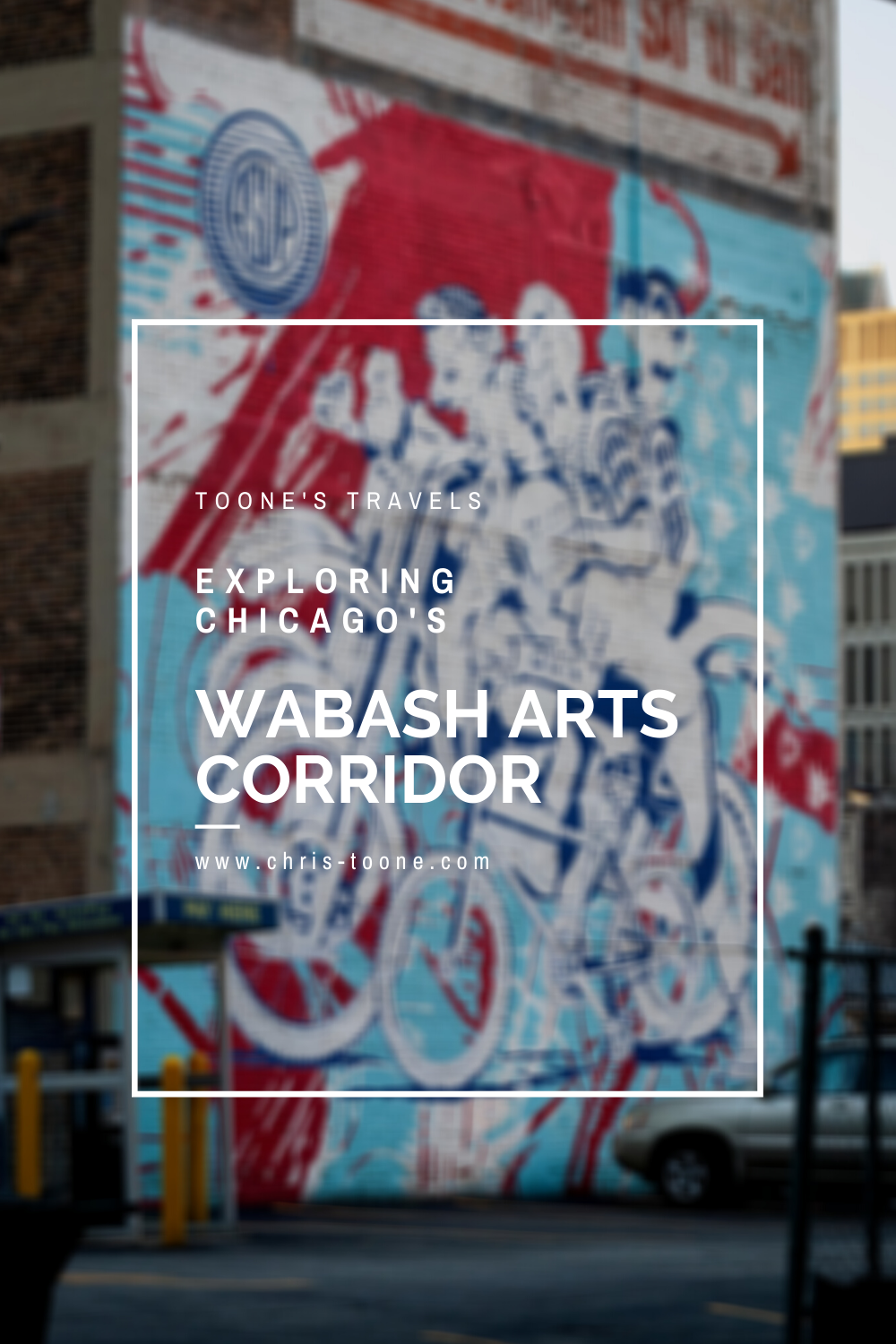
Exploring Chicago's Wabash Arts Corridor
Commonly known as a “living urban canvas” because it’s constantly being added to, Chicago’s Wabash Arts Corridor feels like an open-air museum full of reclaimed public space. It’s collection of street art is one of the most diverse and expansive in the world, making it the perfect way to experience the Windy City’s South Loop neighborhood!
It was just my luck that a week after I moved to Chicago last year, the world seemingly stopped, shutting everything down in the process.
I’d be lying if I said I wasn’t frustrated at first. It’s my second nature to instantly get out and explore a new place, but that didn’t seem possible here.
Here’s what I didn’t realize: Chicago is actually a mecca for street art in the Midwest. Each neighborhood seemingly has its own collection of masterpieces, making it feel as though you’ll discover something new at each turn. With the bright colors, thought-provoking illustrations, and sheer volume of images, the city is basically one large open-air museum.
One of the most expansive, diverse, and well-known street art destinations in the city is the Wabash Arts Corridor (WAC) in the South Loop neighborhood.
Here’s what you need to know.
Want to capture some memories during your time in Chicago? Be sure to check out this post:
KNOW BEFORE YOU GO
The Wabash Arts Corridor was founded in 2013 by Chicago’s Columbia College. Since then, it has grown to be one of the most “expansive, diverse, and accessible public art programs in the country” according to the WAC website.
Beginning in 2016, the corridor shifted its focus to promoting diversity, equity, and inclusion and, in that time, has amassed one of the largest collections of street art created by people of color and women artists.
Pretty sweet, huh?
Many people refer to the Wabash Arts Corridor as a “living urban canvas” due to the fact that new murals are constantly being added and, as a result, public space is reclaimed and transformed into an immersive experience.
Most of the art can be viewed from the sidewalk, making it the perfect sunny day activity that’s free of charge.
The southern border of the corridor is Roosevelt and runs as far north as VanBuren. Within that space, the artwork is scattered within two city blocks running east to west, Michigan Ave to State St.
To get there, take the ‘L’ train to Roosevelt Station (red, orange, green lines) and make your way north along Wabash Ave.
Don’t forget to walk “off the path” and into the alleys. You never know what’s waiting around the next corner!
Before you go, be sure to print off the downloadable map online. This will greatly help along the way. If solo exploring isn’t for you, then it’s easy to sign up for a guided tour ($18/$12/free, adults/students K-12 & seniors/children under 5)!
THE ARTWORK
The Wabash Arts Corridor map lists 30+ pieces of artwork, so this list by no means encompasses each one.
After all, you don’t want me to spoil everything for you, right?
Without further ado, here are some of my favorite murals found thus far:
IMPOSSIBLE MEETING
Artist: Marina Zumi | Location: 901 S. Michigan
Artist Marina Zumi traveled from her home in Sao Paulo, Brazil in 2016 to complete this fantasy-depicting mural. The pastel colors expose an otherworldly scene that are signature to her pieces around the globe, including in Berlin, London, Buenos Aires, and more.

I AM YOU, YOU ARE ME
Artist: Ricky Lee Gordon | Location: 634 S. Wabash
Ricky Lee Gordon is a South African artist whose work tends to depict interconnectedness. It’s fitting as the word Ubuntu originates from the southern part of the continent and is translated as I am, because you are. This mural is easy to miss, so keep a close eye out.

STARS & STYLES
Artist: DMNOLOGY | Location: 618 S. Wabash
DMNOLOGY is known as a graffiti sorcerer of sorts. A homegrown artist, he labels his style as “Wild Onion,” paying homage to the indigenous meaning of Chicago from the Algonquin language.

FROM BOOM TO DOOM
Artist: Collin van der Slujis | Location: 1006 S. Michigan
Collin’s mural features a yellow-headed blackbird that was once common to the area but has since disappeared due to a loss of habitat from invasive species and poor land management. This piece of work stands as a reminder to protect the environment around us.

MAKE YOUR OWN LUCK
Artist: ASVP | Location: 1 E. Balbo
Part of the Vertical Wall Gallery’s “Power of Paint” series, Brooklyn duo ASVP created this piece to express using art to help others. A portion of each sale was donated to the charity of their choice.

STOP TELLING WOMEN TO SMILE
Artist: Tatyana Fazlalizadeh | Location: 801 S. Wabash
Is the title a little uncomfortable for you? Good. Brooklyn artist Tatyana Fazlalizadeh set out to depict the pervasiveness of street harassment by highlighting the faces of 25 young women that have been catcalled while going about their daily life.
She nailed it.

UNTITLED
Artist: Lady Lucx & Sarah Stewart | Location: 525 S. Wabash
Lady Lucx utilized the location as inspiration for this piece, noting that the view from the parking garage includes the orange line of the ‘L’ train as it transitions from the south side of Chicago into the bustling loop.
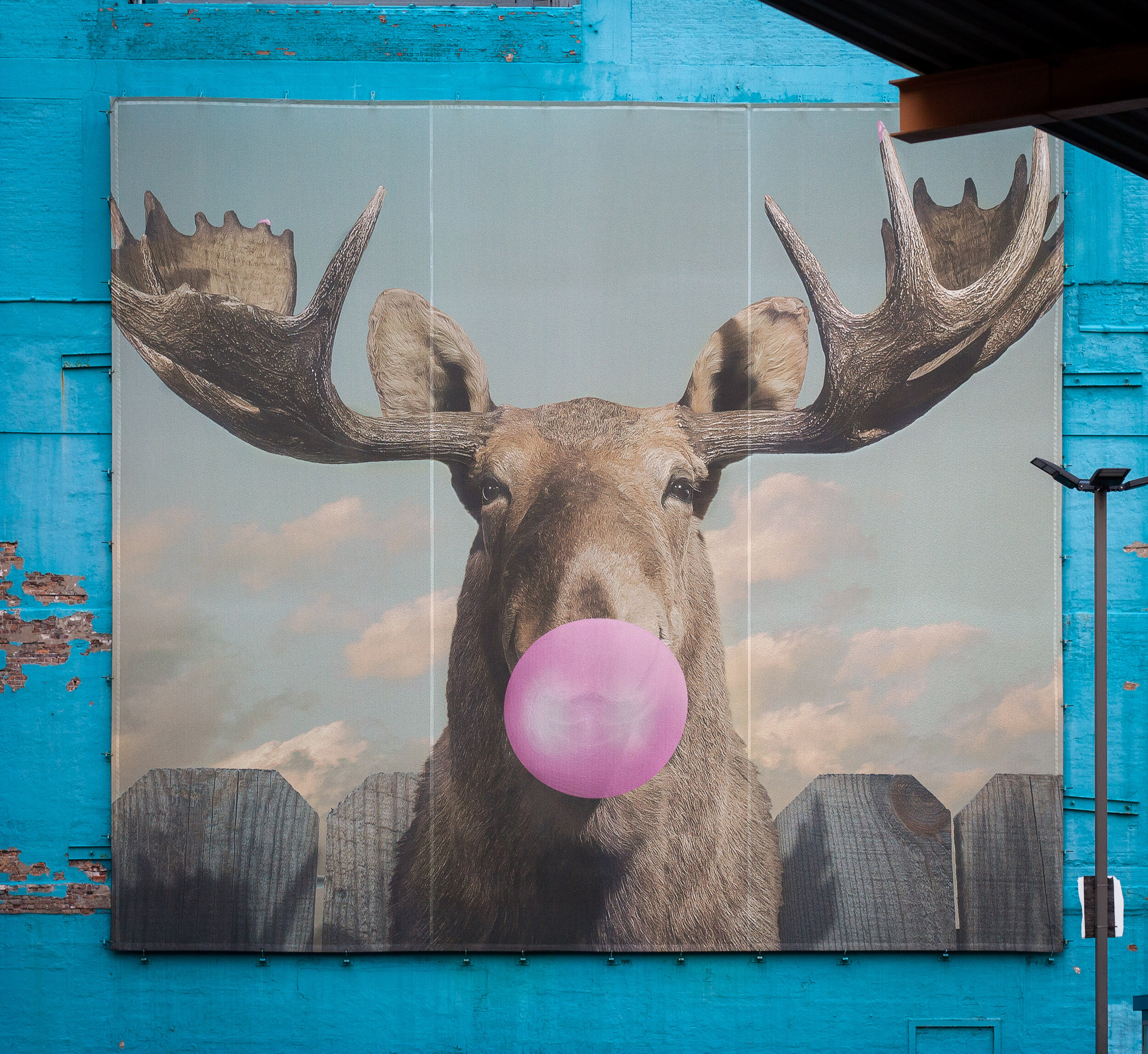
MOOSE BUBBLEGUM BUBBLE
Artist: Jacob Watts | Location: 33 E. Congress
Columbia College launched a student and alumni competition in 2014 and Moose Bubblegum Bubble was selected as the winner. This is one of the most iconic pieces in the Wabash Arts Corridor and can be seen while riding the ‘L’ train south into Roosevelt or north from the same station.
Come explore and bask in Chicago’s open-air museum. The Wabash Arts Corridor may be the most established and well-known collection of street art in the city, but it is by no means the only one. Be sure to check out some of the city’s other neighborhoods and see what you can discover!
Stay safe & happy travels.
Enjoy this post? Pin it and share with your friends!


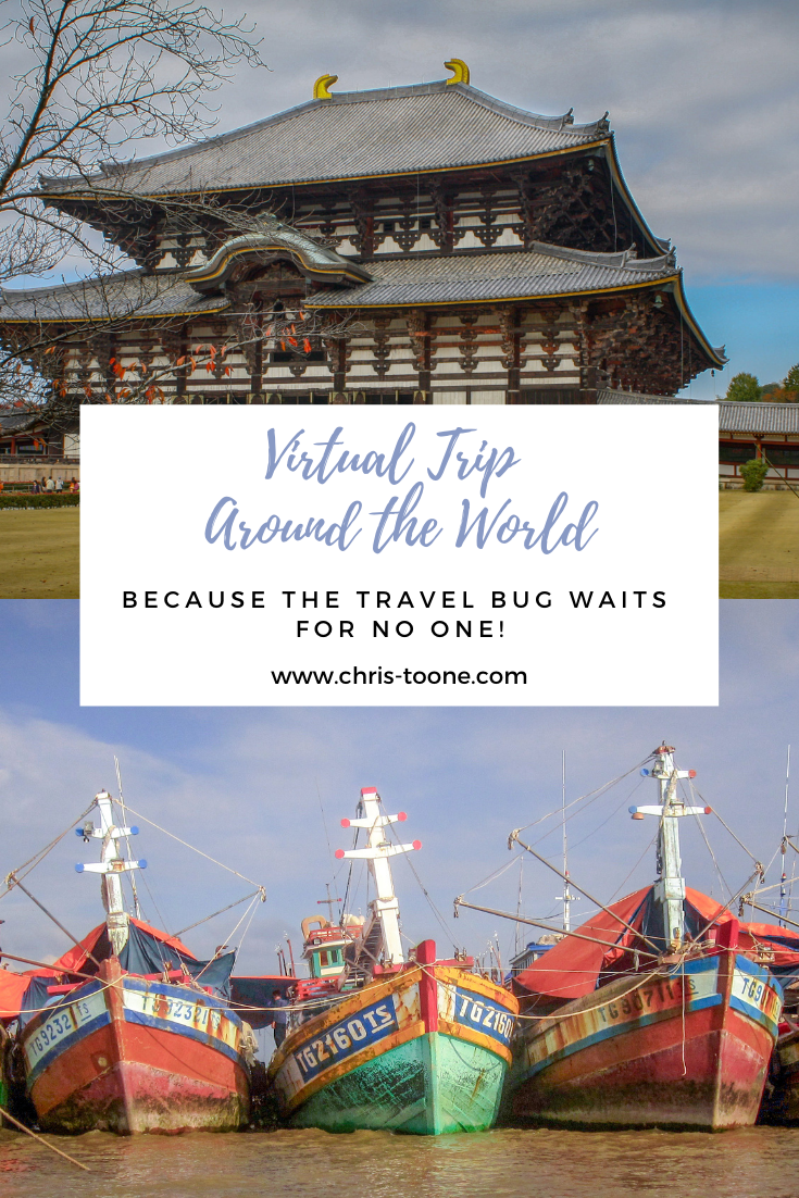
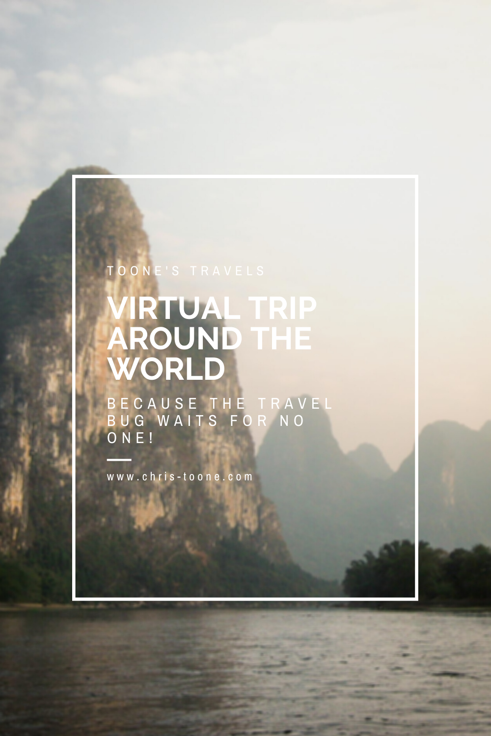
Virtual Trip Around the World: Because the travel bug waits for no one!
It's no secret that the travel bug waits for no one. Follow along on my Semester at Sea itinerary from 2010 and travel the world from the comfort of your couch. 110 days, 12 ports, 10 countries, and 4 continents later, you'll have traveled around the world and be equipped with the knowledge you need to plan your next great adventure!
It’s no secret that this past year has been full of difficulty and challenges, especially for those of us that have perpetually itchy feet and are used to exploring new places. Despite it all, it’s important to continuously remind ourselves that a global pandemic isn’t forever and the time will come when we can get back on those dusty, off the beaten path roads around the world.
Until it’s safe to do so, we’ll have to settle for curbing our wanderlust through virtual trips, books, and documentaries.
The below itinerary is what I was fortunate enough to follow while studying abroad on Semester at Sea in 2010. Consisting of 110 days, 12 ports, 10 countries, and 4 continents, this post is less about my personal experience and more about taking you on a trip around the world to discover something new because, after all, the travel bug waits for no one!
Grab your favorite first-class cocktail, recline back in your seat, and let’s take off!
Interested in learning more about my Semester at Sea experience? Check out this post:
CANADA
Official Languages: English, French | Area: 9,970,610 sq-km | Population: 37.59 million | Capital City: Ottawa | Currency: Canadian Dollar
From sea to shining sea, experience everything from the rugged Atlantic coast in Newfoundland to the foggy Pacific in British Colombia. Get lost exploring the bustling cities of Toronto, Montreal, and Vancouver or push north into the Yukon Territory and chase the northern lights during the winter months. As such a large country, it’s hard to comprehend all that Canada encompasses.
SEE & DO:
Get soaked on the Maid of the Mist at the 8th Wonder of the World, Niagara Falls.
Eat your way through Toronto’s diverse neighborhoods. Over 250 ethnicities and 170 languages are represented in the region.
Explore Quebec City’s Old Town, a registered UNESCO Heritage Site.
Be humbled by the awe-inspiring Canadian Rockies and visit the towns along the way such as Lake Louise, Banff, or Kananaskis.
Experience the way of life along the North Atlantic Ocean in Newfoundland and scope the icebergs, cliffs, and more.
Get your camera ready to capture the abundance of wildlife, including moose, black bears, and grizzly bears.
EAT: Poutine. A glob of french fries, cheese curds, and gravy sauce, this is sure to keep you warm during the blistering winters!
DRINK: Molson. Not only is it the oldest beer in Canada, it’s also the oldest brewery in North America (1786).
WATCH: Montreal, Samantha Brown’s Places to Love S1E12 (PBS).
ONE WORD: “Eh”. Canadians have not one, not two, but ten popular functions of the word. Pretty neat, eh?
KNOWN FOR: Hockey, cold winters, diversity, Tim Hortons, rocky coasts, abundant wildlife, friendly people.
RANDOM FACT: Regina, the capital of Saskatchewan, sits along the geographical center of North America.

Parliament Building, Ottawa

Canadian Rockies

Tourists ice skate on the famous Lake Louise
SPAIN
Official Language: Castilian Spanish | Area: 40,525,002 sq-km | Population: 46.94 million | Capital City: Madrid | Currency: Euro
Spain is high on food and social scenes, so much so that it’s rare you’ll never be steps away from a glass of sangria and a table full of tapas. The country is overflowing with vibrant culture and intricate architectural wonders. Wander, eat, sleep, repeat, and don’t forget to loosen those belt buckles! You’ll thank me later.
SEE & DO:
Bask in the glorious view of the world-famous Alhambra in Andalucía.
Indulge in an evening full of sangria and tapas hopping between bars.
Get lost in the rhythm of a live flamenco performance.
Gawk at the intricate tiles of the Plaza de España.
Step back in time and watch professional Matadors elegantly maneuver around charging balls. Note: watching the bulls die isn’t for everyone. Do your research ahead of time and know what to expect.
Relax on the pristine beaches and explore the secluded coves of Mallorca.
Pack a bag and hike a section of the famed Camino de Santiago.
EAT: Paella, but be sure to wash it down with a couple of delectable churros.
DRINK: Sangria.
WATCH: Spain, Anthony Bourdain: No Reservations S4E14.
ONE WORD: Siesta. It’s no joke here!
KNOWN FOR: Flamenco, delicious tapas, siesta and fiesta, Pablo Picasso, Salvador Dali, Antoni Gaudi.
RANDOM FACT: There are several words in Spanish with no direct translation, including Friolero, that person whose fingers are always white while yours are fine, and Pardo, the color between grey and brown.

A matador narrowly evades a charging bull in Sevilla
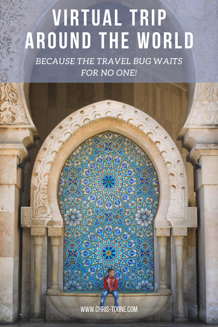
MOROCCO
Official Language: Arabic | Area: 504,782 sq-km | Population: 36.03 million | Capital City: Rabat | Currency: Moroccan Dirham
Located a stone’s throw away from the Spanish coast, Moroccan culture is seamlessly blending the new with the old. The ancient medina walls offer a glimpse into past kingdoms while the streets of Casablanca are brimming with a new generation of chic youth.
SEE & DO:
Fine tune your bartering skills at the Djemaa el-Fna square in Marrakesh. Stick around after the sun goes down and feast at one of the open-air food carts.
Get lost in the ancient Medina of Fez and follow your nose to one of the ancient leather tanneries.
Pay a visit to a local hammam, a traditional Moroccan bath.
Trek through the Atlas Mountains and immerse yourself in the Berber culture.
EAT: Couscous (crushed and steamed balls of durum wheat and topped with heaps of vegetables or meat).
DRINK: Mint tea, a staple of the Moroccan culture.
WATCH: Marrakesh with Chrissy Teagen, Breakfast Lunch & Dinner S1E2 (Netflix).
ONE WORD: Labas, how are you?
KNOWN FOR: Sahara Desert, tagine, Chefchaouen (a village where very house is painted blue), abundance of spices, Atlas Mountains.
RANDOM FACT: The minaret of Casablanca’s Hassan II Mosque rises to 210m and is the largest in the world while the mosque itself holds 25,000 worshipers at prayer.

The Hassan II Mosque’s minaret towers over visitors

A boy sits at the Hassan II Mosque in Casablanca
GHANA
Official Language: English | Area: 446,550 sq-km | Population: 29.77 million | Capital City: Accra | Currency: Cedi
Commonly touted as "Africa for beginners," tourists love visiting Ghana because of its laid-back atmosphere, colorful culture, and ease of travel. To truly understand the people, pay a visit to one of the several slave castles that dot the coast and learn how the country became the first African nation to achieve independence in 1957.
SEE & DO:
Wander through the canopy at 40m above the forest floor in Kakum National Park.
Walk with elephants at one of Africa’s cheapest safaris in Mole National Park.
Soak up the sand between your toes and sleep in a thatched hut at Maranatha Beach Camp.
Get turned around in Accra’s Makola Market, but somehow still find everything you need.
Allow yourself to be overcome with emotion at one of Ghana’s forts as you stare at the ominous “Door of No Return” where slaves once left their homeland behind.
Experience all that Kejetia Market, West Africa’s largest, has to offer in Kumasi.
EAT: Fufu and bofrot (Ghana’s version of a donut).
DRINK: Palm wine from a villager’s homemade stash.
ONE WORD: Hani-Wodzo, let’s dance!
KNOWN FOR: Coastal forts, high-life vibes, beautiful beaches, colorful culture, “Africa for beginners”, friendly people.
RANDOM FACT: 20% of all cocoa beans come from Ghana, making this West African nation the second largest producer in the world.

A visitor carefully navigates the swinging canopy walk at Kakum National Park

Maranatha Beach Camp, Ghana
SOUTH AFRICA
Official Languages: Afrikaans, Venda, Tsonga, English, Southern Soto, Swati, Zulu, Tswana, Ndebele, Xhosa, Northern Soto | Area: 1,219,9090 sq-km | Population: 57.78 million | Capital Cities: Pretoria (administrative), Bloemfontein (Judicial), Cape Town (Legislative) | Currency: Rand
It wasn’t until 1994 that a democratically-elected government took control of South Africa, making it a relatively young country in regards to independence. The effects of the previous regime’s ruthless apartheid policy can still be felt throughout the nation, but the people are determined to rebuild a better tomorrow.
SEE & DO:
Hike to the top of Table Mountain and Lion’s Head Peak for stunning views over Cape Town.
Take the ferry to Robben Island and learn how apartheid ravaged the country until 1994 when the first democratic government was formed.
Bushwalk through Kruger National Park and spot elephants and zebras at dawn.
Travel to the Cape of Good Hope, South Africa’s southern tip. Be sure to make time to visit the penguins at Boulder Beach as well.
Trace the path of the FIFA 2010 Soccer World Cup, the first and only held on African soil.
Need more trip ideas? Check out these activities!
EAT: Vetkoek, a multi-use pastry commonly stuffed with minced meat and eaten as a savory snack or topped with jam for dessert.
DRINK: Wines from the Cape Winelands, Springbok shot (paying homage to South Africa’s national rugby team, the shooter combines creme de menthe and Amarula).
READ: Nelson Mandela’s inspiring autobiography, Long Walk to Freedom, and Archbishop Desmond Tutu’s emotional account of the Truth & Reconciliation Committee as the nation embarked on a long and painful healing process after apartheid, No Future Without Forgiveness.
WATCH: Cape Town, Somebody Feed Phil S2E5 (Netflix)
ONE WORD: Ubuntu (I am, because we are; a testament to the interconnectedness of humanity).
KNOWN FOR: Table Mountain, Springboks Rugby, Kruger National Park, Nelson Mandela, Archbishop Desmond Tutu, freedom fighters, unity.
RANDOM FACT: There are more than 2,000 shipwrecks off the coast of South Africa that date back 500 years.

Lion’s Head Peak at Sunset, Cape Town
MAURITIUS
Official Language: English, French, Creole | Area: 2,040 sq-km | Population: 1.265 million | Capital City: Port Louis | Currency: Rupee
Frequently overshadowed on a map by its neighbor, look for a small dot to the east of Madagascar and you’ll find Mauritius. A tiny island full of pristine beaches, creole cuisine, and stunning highlands, it’s a slice of paradise in the Indian Ocean.
Craving to learn more about Mauritius?
Check out this post:
SEE & DO:
Visit the cascading Chamarel Falls and mesmerizing Seven Colors of the Earth.
Hike through Black River Gorge National Park.
Relax on the beaches of Grand Baie.
Wander through the lively Port Louis Market.
Walk around the Sir Seewoosagur Ramgoolom Temple.
EAT: Camarons (freshwater prawns in spicy sauce).
DRINK: Phoenix Beer from Mauritius’ largest brewery.
ONE WORD: Kreol Morisien (Welcome).
KNOWN FOR: Phoenix beer, beach resorts, land of the lost dodo bird, sugar cane plantations, religious tolerance, island vibes.
RANDOM FACT: Electricity from sugar cane accounts for 14% of the island’s needs.

Seven Colors of the Earth

Black River Gorge
INDIA
Official Languages: English, Hindi, Bengali, Telugu, Marathi, Tamil, Urdu, Gujarati, Malaalam, Kennada, Oriyu, Punjabi, Assamese, Kashmiri, Sindhi, Sanskrit | Area: 3,287,263 sq-km | Population: 1.353 billion | Capital City: New Delhi | Currency: Indian Rupee
India often feels like a world of its own with so much diversity between north, south, east, and west. Traveling here requires stepping out of your comfort zone with all of the sights, sounds, and smells constantly overwhelming the senses, but it’s worth the effort.
SEE & DO:
Float down the Ganges River at sunrise in Varanasi and observe the morning cleansing and cremations along the ghats on shore.
Stand speechless at the entrance to the Taj Mahal.
Ride an overnight train for a true Indian experience.
Navigate rush hour in the gridlocked cities of Mumbai and Kolkata.
Catch a glimpse of Mt. Everest in Darjeeling.
EAT: Chaat (a savory snack served at roadside stalls).
DRINK: Scalding hot chai tea, lassy (a refreshing sweet or salty yogurt shake).
READ: Around India in 80 Trains by Monisha Rajesh.
ONE WORD: Dayaf, baya, sidha (right, left, straight, because a trip to India almost certainly requires directing your rickshaw).
KNOWN FOR: Holy cows, Taj Mahal, Gandhi, Himalayas, towering temples, Bollywood, hectic driving, Holi Festival.
RANDOM FACT: The Taj Mahal’s dome was covered in bamboo scaffolding in 1942 as a way to protect and disguise it from German bomber planes during World War II.

Mid-day viewing of the Taj Mahal with the masses.
SINGAPORE
Official Languages: Chinese, Malay, Tamil, English | Area: 697 sq-km | Population: 5.64 million | Capital City: Singapore | Currency: Singapore Dollar
Careful not to break the rules here as it’s known for strict regulations. Even chewing gum finds itself on the list of banned substances, but don’t be deterred. Singapore might be small in size, but it’s a cultural melting pot of food and people.
SEE & DO:
Wander the Waterloo St. temples and markets.
Soak up the sights, smells and sounds of Little India, Singapore’s ode to the bustling subcontinent.
Swim high above the city at one of the most famous infinity pools in the world, located at the Marina Bay Sands Hotel.
Enjoy a cold drink at Clarke Quay, a popular riverside hangout with plenty of bars and restaurants.
Take in a bird’s eye view aboard the Singapore Flyer, the city’s iconic ferris wheel.
Check out these guides for a comprehensive list of things to do in Singapore!
EAT: Any and all hawker food. Singapore is a place where cultures converge, so it’s only fitting that you try all it has to offer.
DRINK: Tiger Beer, Singapore Sling.
WATCH: Singapore, Somebody Feed Phil S4E3 (Netflix).
ONE WORD: Kiasu. This represents a person’s fear of losing, something that is a staple of sorts within the population.
KNOWN FOR: “No Durian” signs, strict laws including hefty fines for spitting and littering, Tiger Beer.
RANDOM FACT: Singapore is the world’s largest exporter of exotic aquarium fish.

Downtown Singapore
VIETNAM
Official Language: Vietnamese | Area: 331,210 sq-km | Population: 95.54 million | Capital City: Hanoi | Currency: Dong
Organized chaos is the best way to describe the buzzing streets of Saigon as motorbikes whiz by. For a country ravaged by war, the Vietnamese people are a smiley bunch that are eager to show their homeland to everyone and anyone willing to visit. Fresh food, friendly faces, and never a dull moment; what more do you need?
SEE & DO:
Slurp a steaming bowl of pho from the comfort of a rickety plastic stool on the streets of Ho Chi Minh City.
Hire a local fisherman and float the back channels of the Mekong Delta.
Play a game of human frogger in the cities as you try to dodge motorbikes from all directions before giving up and riding one yourself.
Explore the picturesque terraced rice fields in Sapa.
Live on a boat amidst the towering rock formations of Ha Long Bay.
EAT: Pho, Goi Cuon (spring roll).
DRINK: Cafe sua da (Vietnamese iced coffee, also known as crack coffee).
WATCH: Vietnam, Anthony Bourdain: Parts Unknown S4E4.
ONE WORD: Thu’o’ng (th-uong) which describes something that is more than love.
KNOWN FOR: Conical hats, scooter mayhem, Mekong Delta, pho, “same same but different”.
RANDOM FACT: According to ancient Vietnamese folklore, Vietnamese people are descendants of dragons.

Boats docked along the Mekong Delta

A fisherman navigates the offshoot rivers of the Mekong Delta
HONG KONG
Official Languages: Chinese Cantonese, English | Area: 1,110 sq-km | Population: 7.45 million | Capital City: Central | Currency: Hong Kong dollar
Most recently, Hong Kong has created headlines around the world as tensions with China have reached a boiling point. Needless to say, the tiny island is living through a turning point in its history with new, more restrictive regulations. There’s only one question: what will the outcome be?
SEE & DO:
Explore Sham Shui Po, one of the oldest districts in Hong Kong that’s known for it’s textile industry.
Hop aboard the iconic Star Ferry for some of the best views of the city’s skyline from Victoria Harbour.
Reach the top of “The Peak”, the city’s best birds eye view, and marvel at the sheer magnitude of the metropolis below.
Be hypnotized by the extensive evening light show of downtown’s buildings.
EAT: Street food. Widely available, affordable, and a great snack for exploring. Some popular ones include curry fish balls, pineapple buns, and egg tarts.
DRINK: Red bean ice (red beans, sugar syrup, and milk).
WATCH: Hong Kong, Samantha Brown’s Places to Love S2E1 (PBS).
ONE WORD: Gay-dor-cheen-ah (how much is this?) because let’s face it, Hong Kong isn’t the cheapest place to visit in the world.
KNOWN FOR: Skyline views, Victoria Harbour, dim sum, luxury shopping, and political strife with China.
RANDOM FACT: Hong Kong means “fragrance harbor” in Cantonese.

Hong Kong as seen from the top of the The Peak
CHINA
Official Language: Mandarin | Area: 9, 596,961 sq-km | Population: 1.39 billion | Capital City: Beijing | Currency: Chinese Yuan
China is an intellectually intriguing nation to visit. On the surface, the vast country is filled with stunning scenery found nowhere else in the world, but dig a little deeper and the government’s harsh policies rear their ugly head. Where do you fall on this spectrum? One must visit to find out!
SEE & DO:
Hike the Great Wall of China.
Be humbled at the shear vastness of the country by taking a train from east to west.
Head to Yangshuo and float the Li River amongst the towering peaks that seemingly shoot straight up towards the sky.
Observe, learn, and practice T’ai chi each morning in one of the peaceful parks.
Walk the famous Shanghai Bund.
Uncover the 6,000 sculptures of Xi’an’s terracotta warriors.
Need help planning your trip? Here’s a list of curated guides to help!
EAT: Sichuan cuisine and it’s iconic fiery pepper seasoning.
DRINK: Tea at a traditional teahouse where the leaves are rolled, brewed, and roasted for an unmatched and unimaginable aroma.
READ: Peaks on the Horizon, a harrowing tale about one man’s escape from Chinese Authorities in Tibet.
ONE WORD: Ren, meaning to endure.
KNOWN FOR: Calligraphy, t’ai chi, Olympic Games, holistic medicine, the “ghosts” of Tibet, an up and coming wine industry, ancient culture.
RANDOM FACT: China is recognized by the Federation of International Football Association as having the oldest documented version of soccer during the Han Dynasty, over 2,000 years ago. The game was called “Tsu’ Chu” which translates as “kicking ball”.

The city of Guilin, the gateway to Yangshuo

Bamboo rafts float down the Li River in Yangshuo
JAPAN
Official Language: Japanese | Area: 377,915 sq-km | Population: 126.5 million | Capital City: Tokyo | Currency: Yen
No trip to Japan would be complete without venturing outside of the futuristic cities and into the past. The country prides itself on preserving its ancient culture, making it easy to stumble upon relics from throughout history. While you’re at it, be sure to take a deep dive into the food scene that awaits.
SEE & DO:
Hop between 7-11 and Lawsons for the quintessential Japanese convenience store meal, a staple of traveling through the country.
Get lost in busy streets of Tokyo and visit the world’s largest crosswalk at Shibuya.
Explore the zen gardens in Kyoto while trying to spot Geishas.
Confront the dark history of the world at Hiroshima and Nagasaki.
Play with the deer in Nara, Japan’s ancient capital.
EAT: Sashimi, ramen, and gyoza.
DRINK: Shochu, the national spirit of Japan.
READ: Rice Noodle Fish, an unmatched culinary adventure through Japan’s food culture.
WATCH: Japan: Hokaido, Anthony Bourdain: No Reservations S7E8.
ONE WORD: Danryoku-sei, meaning resilient.
KNOWN FOR: Mt. Fuji, cherry blossoms, sushi, sumo, anime, kimonos, and Tokyo’s massive public transport system.
RANDOM FACT: Japan’s rail system is one of the most efficient and on-time around the world, so rush hour requires professionally employed “pushers” to make their rounds and shove passengers into the packed car for trains to run on schedule.

Todaiji Temple in Nara, Japan
Voila! You’ve completed a trip around the world. Although the future of travel still seems uncertain, it’s never too early to start planning your next great adventure. At the very least, it takes the edge off the travel bug a bit, right?
Need more information about a destination? Want my personal recommendations? Leave a comment below and let’s start putting your next adventure together!
Stay safe, wear a mask, & happy travels!
Enjoy this post? Pin and share it with friends!
Hello, World!
The Ultimate 3-day Itinerary in Boquete, Panama: Experience cloud forests, coffee, and more!
From ominous cloud forests and lush jungle vegetation to the world’s best coffee bean, Boquete is a magical place nestled within the Chiriquí Highlands of Panama that an adventurer’s dream. Here’s a 3-day itinerary to help you plan your next trip!

First and foremost, let me take a moment to answer the most important question: is three days enough in Boquete?
No.
There’s such a high volume of places to explore and things to experience that it’d be easy to spend weeks, if not a month here. This guide will at least help you to scratch the surface and be well on your way to creating the perfect Boquete, Panama itinerary that works for you!
BACKGROUND
Boquete is a small town located in western Panama about 40 miles from the border with Costa Rica. It’s a place popular amongst travelers and ex-pats alike for the abundance of wildlife, cloud forests, and globally acclaimed coffee beans.
Situated along the Caldera River and surrounded by the Chiquiri highlands, the area offers incredible hiking and outdoor adventures for any age including prime viewing of the elusive Quetzal, Panama’s most popular bird. Visitors will find a unique concoction of both Panamanian culture and cuisine mixed with the ex-pat influence from around the world.
If hiking isn’t your thing, no problem! Visit a coffee farm to learn how Boquete cultivates the world’s most expensive bean, soak up the cloud forest views by driving the Bajo Mano Loop, and even take a chocolate-making class in town. Either way, a trip to Boquete is well worth it!
GETTING THERE
There are three main ways to get to Boquete: car, bus, and plane. Let’s break it down:
Renting a car and driving from Panama City to Boquete will take around 6.5 hours via Route 1. It’s a scenic drive along the highway and allows travelers to take their time, stopping in towns like Santiago and David as they go.
This was the mode of transportation I opted for and although renting a car in Panama is notoriously confusing, it was liberating to have the freedom on the road. Having a car while in Boquete also made the more remote hiking trails more accessible.
The most cost-effective option is via bus. There are direct routes from Panama City to David, in which you’ll then need to transfer to further reach Boquete. Generally speaking, this is what you can expect:
Panama City to David – around 8 hours and $15.75
David to Boquete – 1 hour and $1.75
The quickest and also the most expensive way is via flight from Panama City to David before renting a car or hopping on the local bus. The flight time is around 40min and can cost between $85-$150.
To read more about renting a car in Panama, check out this post!
WHERE TO STAY
Thanks to the ex-pat community, there is a wide range of accommodation available from hostels to bed and breakfasts or fully furnished Airbnb rentals!
Sub - $50
$50-$100
$100+
Hotel Finca Lerida Coffee Estate
During this three-day trip, I opted for an Airbnb at Villa Cascada Boquete and could not have had a better experience! The living space is detached from the main home for complete privacy, including entry, and comes complete with a secluded and relaxing koi pond off the back patio. The location is an easy walk to downtown Boquete and made for the perfect home base.
3-DAY ITINERARY
There are a few quick notes to make regarding the itinerary below.
To start with, I tend to travel as most cost-effectively as possible. Often I opt to save money on fancy meals and put those funds towards more experiences. Also, anyone will tell you that I plan very little and explore a lot. Sometimes it works out and sometimes it leaves me wanting more, but it's a risk I'm willing to take.
With these points in mind, let’s dive into a basic, three-day itinerary in Boquete, Panama!
DAY 1:
Breakfast: I opted for a quick and easy breakfast at the Airbnb before packing snacks and heading to the cloud forest for a morning hike.
Two of the best grocery stores to stock up on easy meals and snacks are Super Barú Boquete and Romero Boquete.
Pipeline Trail: The Boquete area has such an abundance of trails to explore that it can be quite overwhelming to choose one to do, especially if on a limited time. This was my first experience hiking in the jungle, so I chose the Pipeline Trail as it’s well known, clearly marked, and relatively flat. Due to the popularity, it’s best to wake up early and start the trek first thing in the morning.
This hike takes visitors through the lush jungle along a narrow path and is commonly known as one of the best places in town to view the Quetzal bird. Along the trail lies a massive 1,000-year-old tree, shooting straight up into the jungle canopy.
The gem of this 3.8-mile loop hike is the cascading waterfall that provides the necessary mist to cool off and feel energized for the trek back to the trailhead.
Note: The locals regulate the trail and there is a 5 USD entrance fee per person, as well as a required sign-in/out. As you walk up from the “Welcome” sign at the road, a small hut will be on the left before you enter the jungle.


Lunch: After being energized by the Pipeline Trail, I opted for a quick lunch/rest back at the Airbnb before setting out on another adventure.
Choclón Waterfall: This was an adventure for the ages. As I was researching places to visit in Boquete, I came across a picture of these stunning twin waterfalls and knew I needed to visit. The only problem was there was no location listed.
Armed with loose GPS coordinates and blurry Google Satellite images of the area, I set off to see if I could make it happen.
After hours of trying, re-trying, almost giving up, and then trying yet again (you can read more about the full adventure by clicking here), I finally found the correct path that led to the magical Choclón Waterfall.
The path itself was overgrown, narrow, and isolated, but the short hike down to the riverbed beyond worth the effort!

Dinner: After expending so much energy on the hiking trails throughout the day, it was a stay-in and rest type of night for dinner, only stepping foot outside to reward myself with a delicious dessert from Gelateria La Ghiotta, a frequent stop on my trip.
DAY 2:
Breakfast: Still feeling the effects of a day full of exploring in the sun and humidity, day 2 was more about exploring the downtown Boquete area. After several local recommendations, I settled on a place called Olga’s for breakfast.
Situated in her own home and greeting each customer with a hug and a kiss on the cheek, Olga’s food was by far the best I experienced on my Panamanian adventure!

Daytime Adventures:
La Viuda del Cafe
The Boquete area is well known around the world for cultivating the Geisha coffee bean. With a gentle wildflower aroma, a bag of these can go for $600 and just a cup can cost $64 in Dubai!
Luckily by being at the source it’s much more affordable. La Viuda del Café is a boutique coffee shop that translates literally as “the coffee window.” Here a cup of Geisha coffee costs only $4!
Is the delectable bean that good? Yes, it is, my friends.

Pastelería Alemana
Located south of downtown Boquete and along Route 41 lays Pastelería Alemana.
A small German pastry shop, the outdoor seating area makes for an odd yet perfect experience, eating a scrumptious apple strudel while gazing off at the remote jungle in the distance.
Faro Panama
I had passed this attraction on the drive into town from Panama City and was completely taken aback. How does a giant lighthouse make its way to such a remote part of the country?
Long story short, this family fun center opened just before my arrival in Boquete and I was the only car in the parking lot. It was an ominous feeling to see an empty complex and have the staff so surprised to see a visitor, but the top of the lighthouse provided unparalleled 360-degree views of the area, including Volcan Barú.
The cost was 4.25 USD per person.

Café Ruiz
To fuel up for an evening hike, a quick stop at the Café Ruiz coffee farm was necessary. Nestled out of town and amongst lush flora, the tasting flight of various local coffees was a needed afternoon jolt.
Café Ruiz also offers some of the shorter/cheaper coffee tours in town. I tried to sign up for one but unfortunately, it was full. Lesson learned; book in advance!
Ready to learn more about Panama’s coffee? Check out this tour from Get Your Guide!
La Piedra de Lino
Translated as “the rock of Lino,” this short yet steep hike offers some of the most spectacular views over Boquete and the surrounding cloud forests.
Climbing 1000+ feet in just over 1.5 miles, La Piedra de Lino is a leg burner and not for the faint of heart, but the payout at the top is worth it.
The path can get slippery, especially after a good rainfall. Be sure to wear shoes with good tread and move slowly.

Dinner: Sabrasón
A cafeteria-style buffet full of Panamanian cuisine and incredibly cheap, Sabrasón made for a quick and easy meal after an exhausting and fulfilling hike up La Piedra de Lino.
Dessert: Gelateria La Ghiotta
DAY 3:
Breakfast: Olga’s… again. Enjoying homemade food on the back patio and surrounded by local flora was the perfect way to start the day.
Tuesday Market: If you’re looking to avoid the ex-pat influence, then the Tuesday Market isn’t for you. With that being said, it’s a unique experience in the area as the community congregates to sell local foods and gifts.
Shopping: Finding the right knick-knacks is far cheaper in Boquete than back in Panama City, so before I drove out of town I spent some time wandering up and down the main road while browsing the local selection of blankets, backpacks, and more.
Boquete was a quick stop on a whirlwind trip around Panama and I wish I had been able to spend more time here, but it’s certainly a place that’s high on my list to return to and learn more about.
Questions? Have other ideas for a trip to Boquete? Leave them in the comments below and be sure to check out my other posts about Panama!
Stay safe & happy travels!
Enjoy this post? Pin and share with others!


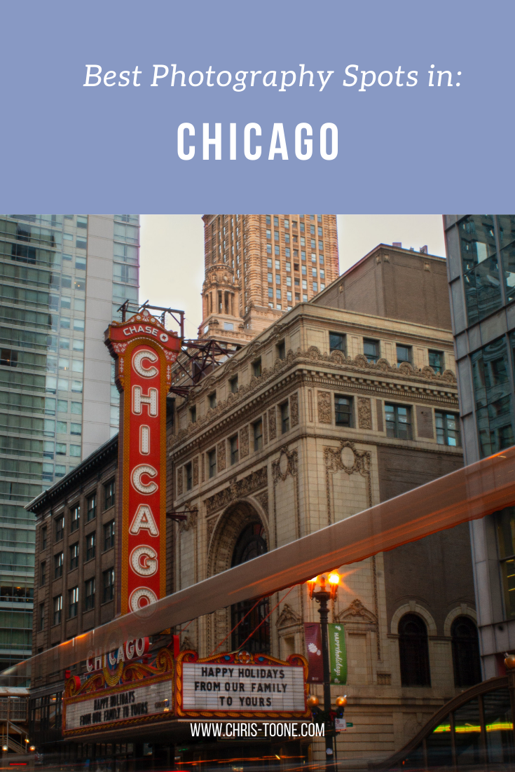
Best Photography Spots in Chicago: Everywhere you need to go on your next trip to the Windy City
Skip the tourist trail and check out this comprehensive list of incredible spots to photography Chicago. From where to find the best city skyline views to which parking garages best capture the 'L' train, this is a must-have guide before your next trip!

As it turns out, moving to Chicago has been the perfect way to expand my photography skills. With the hustle and bustle of city life, the famous ‘L’ train weaving through the towering buildings, and the glistening shores of Lake Michigan to the east, there’s a unique perspective everywhere you look.
Millennium Park and Michigan Ave are by far the most visited sites in this mid-western hub but trust me when I say there’s so much more to discover.
Here’s a list of the best places to photograph Chicago.
NORTHERLY ISLAND
Northerly Island is a peninsula park along the shores of Lake Michigan that comes complete with city skyline views, including the iconic Soldier Field.
Enjoy the fresh air and greenery as you combine your skilled nature shots with that of urban life.
Fun Fact: The 5-acre lagoon is home to many of Illinois’ wildlife, including monarch butterflies and heron.
Getting There: Red, orange, and green line trains to Roosevelt & walk from there

NORTH AVE. BEACH
Located in Lincoln Park, this popular beach offers some of the best skyline scenery in the entire city. Walk the jetty, stick your toes in the sand, and snap some shots as daily life in Chicago moves all around you.
Pro Tip: This is location is adjacent to the Lincoln Park Boardwalk (below), so it’s easy to combine the two shoots.
Fun Fact: North Avenue Beach came into existence from a multi-million project in the 1930s that was partially funded by President Roosevelt’s New Deal. The beach itself is an extension of an old landfill’s narrow path along Lakeshore Drive.
Getting There: Red, brown, or purple express lines to Fullerton & walk towards Lincoln Park

North Ave. Beach in Chicago, IL
ORLEANS ST. BRIDGE
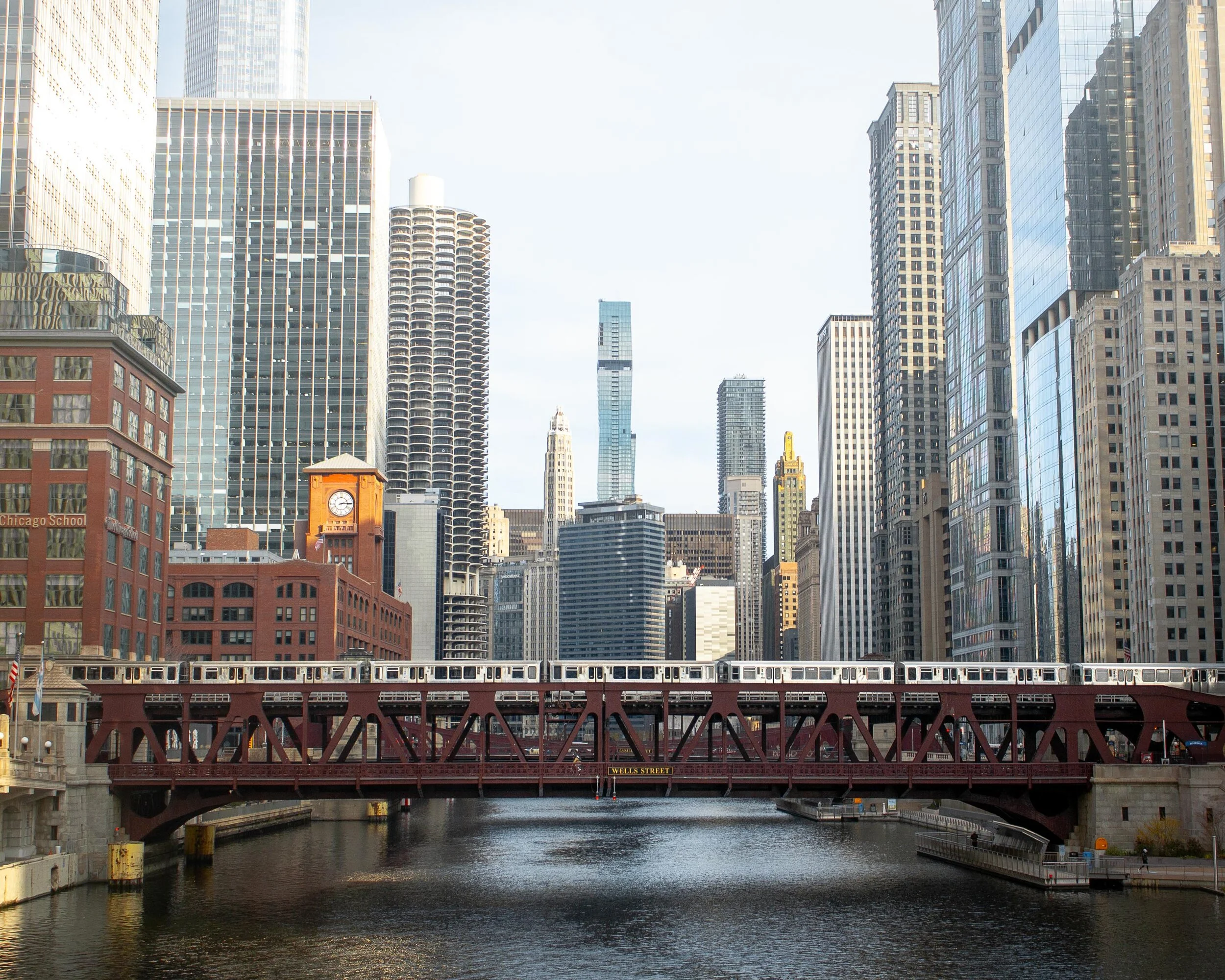
The most popular way to take advantage of this location is to shoot towards the Wells St. Bridge. This is one of my favorite scenes in the city that perfectly encapsulates life in Chicago; boats cruising along the river below, the brown line trains traversing across the river and stunning architecture rising high towards the sky.
A unique feature of Chicago is that the city is constructed in a way that each building seems to command space of its own, demanding attention as an independent masterpiece. This location perfectly captures that.
Pro Tip: Shooting towards the Wells St. Bridge is great, but don’t forget to turn around and check out the trains coming across the Lake St. Bridge as well.
Fun Fact: The two leaves of the Wells St. Bridge were built offsite and then transported via the Chicago River for installation.
Getting There: Blue, orange, pink, green, brown, and purple express lines to Clark/Lake or brown/purple line to Merchandise Mart
Downtown Chicago, IL
WELLS KINZIE GARAGE
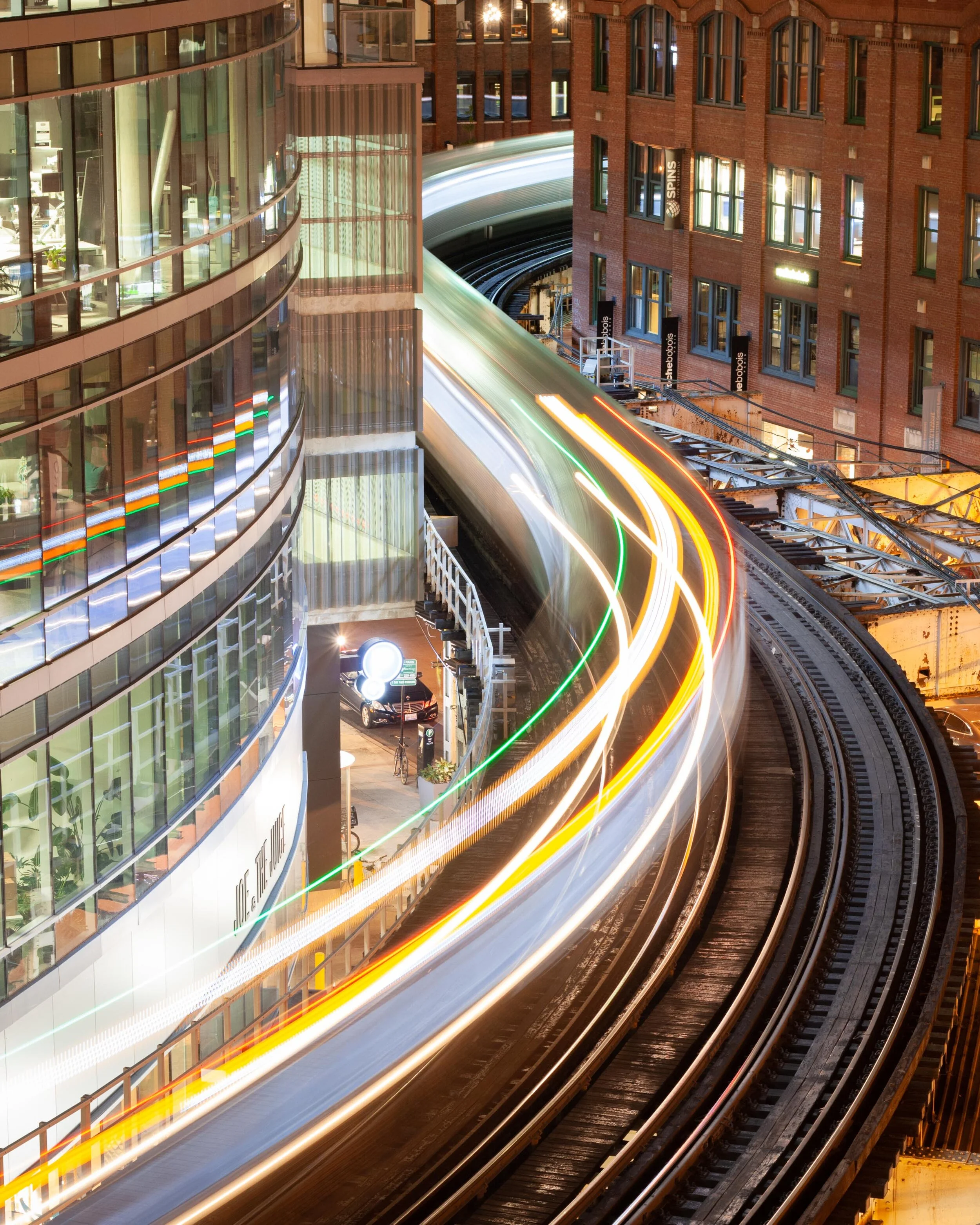
One of my favorite parts of living in the city is finding unique angles to capture the famed ‘L’ train. There’s no better shot than the S-curve in the downtown loop.
Ride the elevator to the top of the Mart Parc Garage at the corner of Wells and Kinzie and watch the trains maneuver through the city’s infrastructure.
Remember: each level of the garage offers a different perspective of the tracks. Be sure to spend some time exploring to find what works best for you!
Fun Fact: In 2014, the “L” train was fourth in the nation for total route length at 102.8 miles.
Getting There: Brown and purple express lines to Merchandise Mart
‘L’ Train in Chicago, IL
437 N. ORLEANS
For the lesser-known view of the S-curve, head to the parking garage located at 437 N. Orleans. The top-level shows the trains as they head to/from the Merchandise Mart CTA station.
Located near the Orleans St. Bridge (above), this makes for a great day of chasing trains.
Pro Tip: For the symmetry enthusiasts, take note of the Assumption Catholic Church steeple against the red brick backdrop.
Fun Fact: The oldest sections of the “L” train began operations in 1892, making it the country’s second-oldest rapid transit system behind New York City’s elevated rail system.
Getting There: Brown or purple lines to Merchandise Mart

‘L’ Train as seen from 437 N. Orleans in Chicago
Need more ideas? Check out this list of curated tours!
PING TOM MEMORIAL PARK
This is the first park I visited after moving to Chicago and it remains at the top of my favorites.
Located in the Chinatown district, this is the perfect place to stock up on some warm buns and pastries, walk along the river, and shoot the city skyline. The boardwalk with the ornate rails helps to create some appealing leading lines.
Pro Tip: Ping Tom Memorial Park is commonly known as one of the best places to watch trains. Amtrak frequently crosses the bridge at the southern edge of the pathway while the CTA trains and freighters flank it to the east.
Fun Fact: This 17.4-acre park was originally the site of a Chicago and Western Indiana Railroad yard. The area began its transformation into a green space in 1998.
Getting There: Red line trains to Roosevelt or green line to Cermak-McCormick Place
Downtown Chicago as seen from Ping Tom Memorial Park
18th STREET BRIDGE
Another spectacular city skyline view is on the 18th Street Bridge, located just above Ping Tom Memorial Park. Point the camera up the South Branch of the Chicago River and behold the Windy City in all its glory.
This is an especially great spot for nightscape photography.
Fun Fact: With a 1967 construction date, the 18th Street Bridge is one of the youngest in all of Chicago.
Getting There: Red line trains to Roosevelt or green line to Cermak-McCormick Place

Chicago skyline as captured from the 18th street bridge in Chicago’s Chinatown
LINCOLN PARK BOARDWALK
The nature boardwalk at Lincoln Park makes for the perfect escape from the busy city streets. The pond is surrounded by prairie-style grass and is full of life with birds, frogs, and fish to name a few.
This is a great place to not only photograph the urban nature scene, but the John Hancock Building as well.
Pro Tip: Combine a visit here with North Ave Beach.
Fun Fact: The Nature Boardwalk acts as a living laboratory for the Urban Wildlife Institute in Chicago as they test new techniques to resolve human-wildlife conflict.
Getting There: Red, brown, or purple express line trains to Fullerton

Lincoln Park, Chicago
200 NORTH CLARK
In a massive city full of high rises, this is the place where you can see straight to the horizon and it feels as though the trains below are riding off into the sunset.
The reflective siding on the garage adds to the unique perspective and helps to create some stunning imagery.
Fun Fact: In 2016, the “L” train had 1,492 cars transporting passengers between 145 stations.
Getting There: Blue, green, pink, orange, brown, and purple express lines to Clark/Lake

The view from the parking garage at 200 N. Clark St. in downtown Chicago
WABASH ARTS CORRIDOR
Commonly referred to as the “living urban canvas” because new pieces are being added on an annual basis, the Wabash Arts Corridor is a unique collection of colorful murals.
Stretching from as far north as Polk and as far south as Roosevelt, this is the perfect place to wander around with your camera. Be sure to check the website for more information, including a walking map of each masterpiece.
One of the most popular works is the Moose Bubblegum Bubble by artist Jacob Watts.
Pro-Tip: Start on the southern edge at Roosevelt and make your way north back into the city’s downtown loop.
Fun Fact: The Wabash Arts Corridor was founded in 2013 by Columbia College and continues to grow into being one of the largest, unique, and accessible art projects in the country.
Getting There: Red, orange, and green line trains to Roosevelt & walk north
Moose Bubblegum Bubble mural by artist Jacob Watts
CHICAGO THEATER
Ok, you caught me. I can feel you rolling your eyes.
The vintage Chicago Theater sign isn’t exactly “off the beaten path”, but it does make for some pretty great long exposure shots and it’s a quick and easy stop on your tour of the city.
Fun Fact: The Chicago Theater was the first large movie palace in America and quickly became the prototype for all others. Constructed in a French Baroque style, look closely at the theater’s exterior to see if you can find the miniature Arc de Triomphe.
Getting There: Pink, green, brown, orange, and purple line express trains to State/Lake

Chicago Theater standing tall in the downtown traffic

The Chicago Theater shines bright in the snow
The truth is you just need to come here yourself and wander around. Each neighborhood, train line, and person has something unique to offer!
Stay safe & happy travels.
Enjoy what you read? Pin this post for later!

The Ultimate Hiking Guide to Mississippi-Palisades State Park
With local travel the name of the game in 2020, it’s time to explore a little closer to home. With bluffs to climb, fall foliage to soak up, and expansive views of the Mississippi River, there’s every reason to visit Mississippi-Palisades State Park! Here’s everything you need to know…
Local travel is the name of the game in 2020 and with autumn in full bloom, it seemed like the perfect time to migrate away from the bustling streets of Chicago and into the woods to soak up all of the colorful glory.
My alarm rang far too early at 5 am, but it was well worth the sleepless night as I rolled into an empty Mississippi-Palisades State Park at the crack of dawn, nestled along the northern section of the great Mississippi River and complete with sweeping views of Iowa across the way.
Picnic areas, grassy fields, and overlooks are in abundance within the 2,500 acre National Natural Landmark, but the goal of the day was to explore the trails and gain some much-needed elevation (I’m still adjusting to living in the midwest — shout out to the Wasatch Mountains back in Utah).
Here’s everything you need to know about hiking in Mississippi-Palisades State Park:
View of the Mississippi River as seen from the Sunset Trail at Mississippi-Palisades State Park
THE BASICS:
Location: Just north of Savanna, Illinois in Carroll County
Established: The park was founded in 1973
Trails: Hiking in the area is divided into the north and south systems, both containing 5 trails of their own for a cumulative 15-miles worth
Note: this post focuses on the southern trail system
Drive Time: 2 hours and 45 minutes from Chicago, depending on the time of day
Cost: FREE!
Facilities: Grills, gazebos, picnic areas, and restrooms can be found throughout the park
Why Mississippi-Palisades: The drive along the Great Northern Road as it pops in and out of small towns is just as stunning as the park itself, but there’s nothing quite like hiking up the bluffs and seeing the sweeping views above the Mississippi River in the peak of autumn
Difficulty: AllTrails rates this 4.6-mile multi-trail loop as ‘difficult’ due to a few sections of steeper terrain, but it’s a great combination of ascent, descent, and level ground. Plenty of families with young children were out and about
Great! Now that we’ve covered the basics, here’s how I spent my time wandering the southern trail system:
SUNSET TRAIL
I’d recommend starting with this trail as early as possible as the Lookout Point is by far the most popular overlook of the Mississippi River within the state park’s southern trail system. It’s here where you’ll soak up the sweeping views of the river and watch trains roll by below for as long as your heart desires.
The steepest part of the trail is departing from the parking lot as you climb the stairs and gain a quick chunk of elevation. Keep in mind that it’s a narrow, single-track dirt path with steep drop-offs to one side, so be on the lookout for other hikers and proceed with caution.
Once you reach the top of the bluff you’ll encounter a road that leads directly to the overlook. Do not head that way. Instead, cross over and continue on the trail. This winding path will take you down into a ravine thick with vegetation, complete with a wooden foot-bridge that’s set beneath a canopy of changing leaves.
As you make your way up and out of the trail’s low-point, you’ll stumble back onto the road and have the opportunity to scope the overlook. Pro tip: If it’s busy, continue south on the trail and you’ll find a separate, unofficial overlook with views downriver.

Sunset Trail in Mississippi-Palisades State Park
SENTINEL TRAIL
Sentinel Trail is an easy 1.2-mile trail that is located directly across the road from the Sunset Trail, next to the picnic shelter and makes for a convenient second loop on the day.
As you cross the bridge and reach the fork, head left. This will take you up another set of wooden stairs and to a t-junction at which point you’ll choose left again. This will take you to an upper parking lot where you will pick up the less-trafficked Pine Trail.
After completing the short Pine Trail loop (see next section), head back up the Sentinel Trail path that led to the parking lot and continue straight past your previous left turn at the t-junction. This will take you back towards the Mississippi River and over to some last-minute views across the water before heading back down to the parking lot via stairs and narrow paths. Be sure to stop and check out some of the caves that have been carved into the side of the bluffs over the years!
Hiking through the narrow trails of Mississippi-Palisades State Park
PINE TRAIL
Pick up the Pine Trail once you’ve reached the upper parking lot after hiking part of the Sentinel. This was by far the least crowded path within the park, making it easy to avoid other hikers and find some serenity among the fall foliage.
After reaching yet another t-junction, head left. This will lead you out to a road in which you then follow to the right to pick up the trail again at the next parking lot.
As you start the ascent from the road you’ll immediately notice a gray spire affectionately known as The Sentinel. This is a popular rock climbing area so don’t be surprised if you run into some dare-devils as you make your way up to the next overlook before looping back into the woods and up to the Sentinel Trail.
In regards to peacefulness, fall foliage, and a great workout of ascending/descending paths, Pine Trail was the highlight of the day!

Fall foliage in Mississippi-Palisades State Park
There you have it; everything you need to know about hiking through Mississippi-Palisades State Park! The family-friendly area makes for a great day-trip from Chicago and it’s easy to turn it into a weekend getaway by continuing north along Route 84 up to Galena, a quaint town once home to Ulysses S. Grant.
Happy hiking!
Enjoy this post? Pin it for later!


