

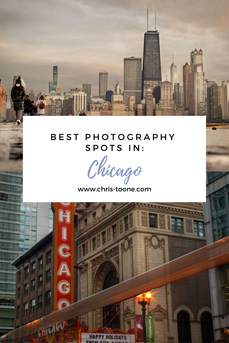
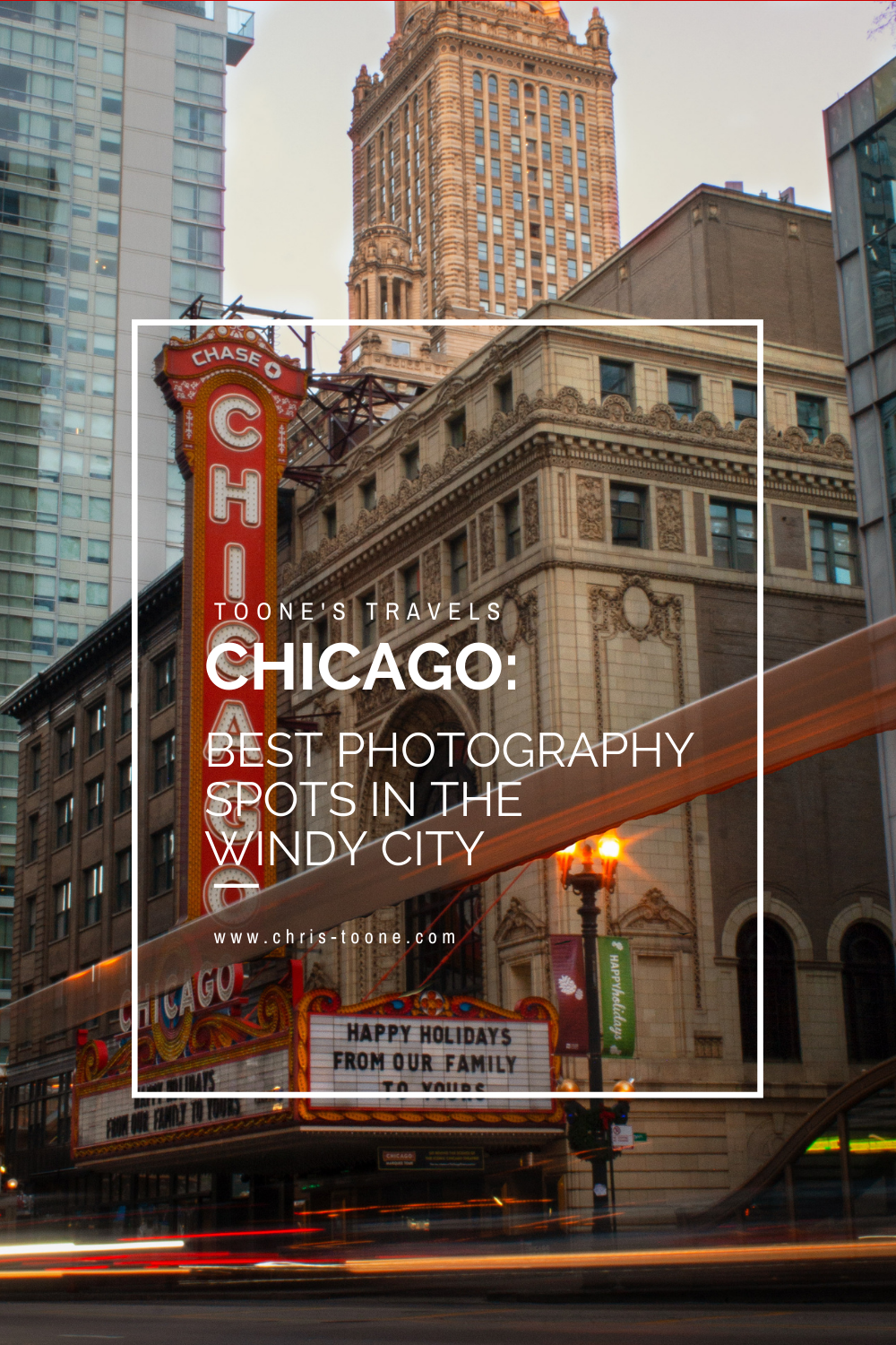
Best Photography Spots in Chicago: Everywhere you need to go on your next trip to the Windy City
Skip the tourist trail and check out this comprehensive list of incredible spots to photography Chicago. From where to find the best city skyline views to which parking garages best capture the 'L' train, this is a must-have guide before your next trip!

As it turns out, moving to Chicago has been the perfect way to expand my photography skills. With the hustle and bustle of city life, the famous ‘L’ train weaving through the towering buildings, and the glistening shores of Lake Michigan to the east, there’s a unique perspective everywhere you look.
Millennium Park and Michigan Ave are by far the most visited sites in this mid-western hub but trust me when I say there’s so much more to discover.
Here’s a list of the best places to photograph Chicago.
NORTHERLY ISLAND
Northerly Island is a peninsula park along the shores of Lake Michigan that comes complete with city skyline views, including the iconic Soldier Field.
Enjoy the fresh air and greenery as you combine your skilled nature shots with that of urban life.
Fun Fact: The 5-acre lagoon is home to many of Illinois’ wildlife, including monarch butterflies and heron.
Getting There: Red, orange, and green line trains to Roosevelt & walk from there

NORTH AVE. BEACH
Located in Lincoln Park, this popular beach offers some of the best skyline scenery in the entire city. Walk the jetty, stick your toes in the sand, and snap some shots as daily life in Chicago moves all around you.
Pro Tip: This is location is adjacent to the Lincoln Park Boardwalk (below), so it’s easy to combine the two shoots.
Fun Fact: North Avenue Beach came into existence from a multi-million project in the 1930s that was partially funded by President Roosevelt’s New Deal. The beach itself is an extension of an old landfill’s narrow path along Lakeshore Drive.
Getting There: Red, brown, or purple express lines to Fullerton & walk towards Lincoln Park

North Ave. Beach in Chicago, IL
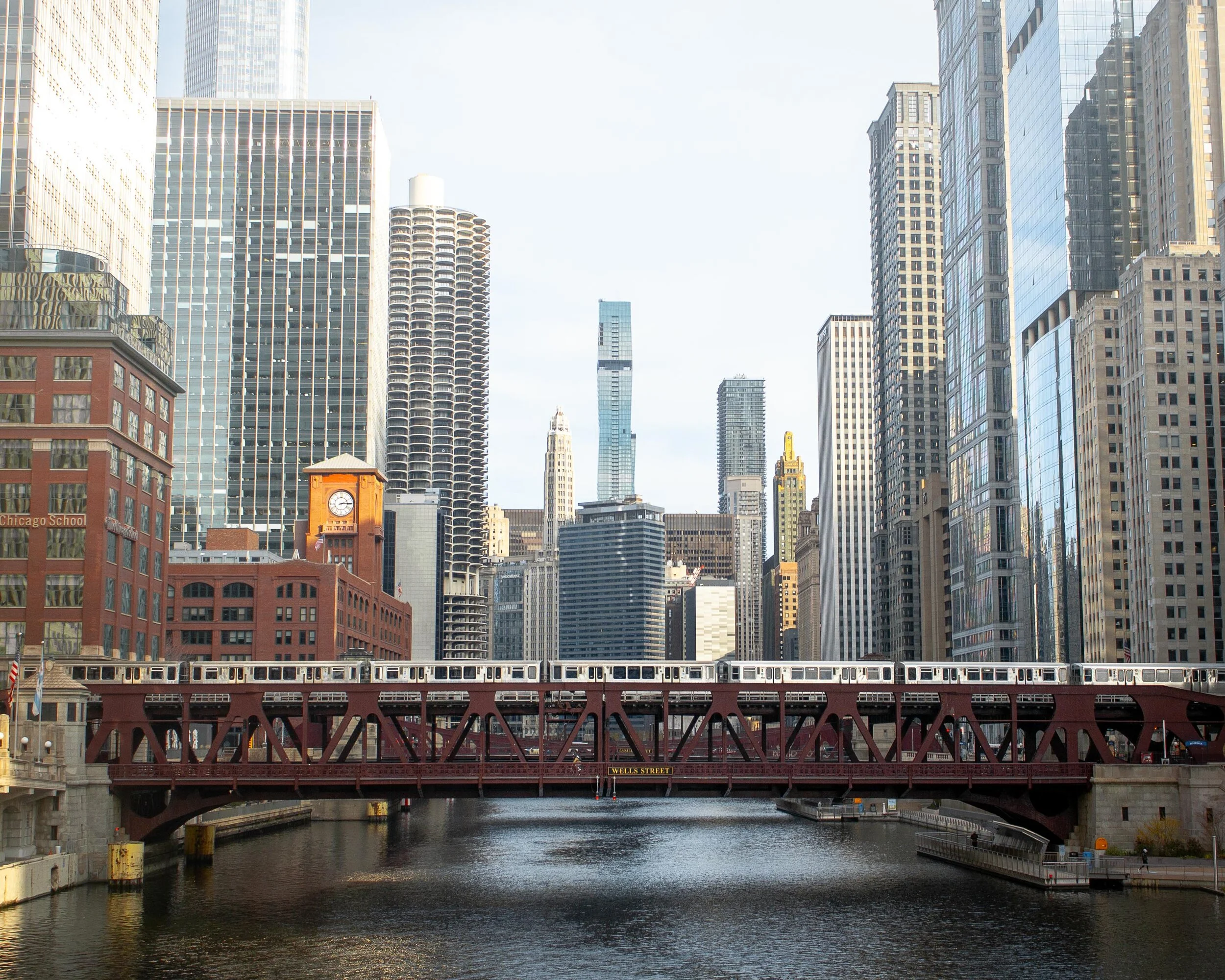
ORLEANS ST. BRIDGE
The most popular way to take advantage of this location is to shoot towards the Wells St. Bridge. This is one of my favorite scenes in the city that perfectly encapsulates life in Chicago; boats cruising along the river below, the brown line trains traversing across the river and stunning architecture rising high towards the sky.
A unique feature of Chicago is that the city is constructed in a way that each building seems to command space of its own, demanding attention as an independent masterpiece. This location perfectly captures that.
Pro Tip: Shooting towards the Wells St. Bridge is great, but don’t forget to turn around and check out the trains coming across the Lake St. Bridge as well.
Fun Fact: The two leaves of the Wells St. Bridge were built offsite and then transported via the Chicago River for installation.
Getting There: Blue, orange, pink, green, brown, and purple express lines to Clark/Lake or brown/purple line to Merchandise Mart
Downtown Chicago, IL
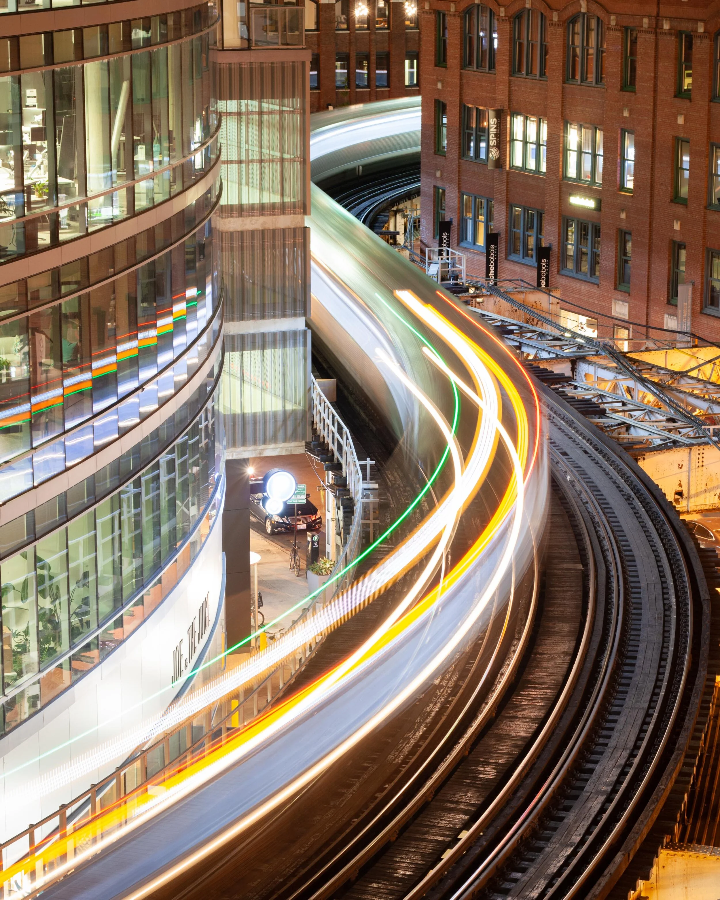
WELLS KINZIE GARAGE
One of my favorite parts of living in the city is finding unique angles to capture the famed ‘L’ train. There’s no better shot than the S-curve in the downtown loop.
Ride the elevator to the top of the Mart Parc Garage at the corner of Wells and Kinzie and watch the trains maneuver through the city’s infrastructure.
Remember: each level of the garage offers a different perspective of the tracks. Be sure to spend some time exploring to find what works best for you!
Fun Fact: In 2014, the “L” train was fourth in the nation for total route length at 102.8 miles.
Getting There: Brown and purple express lines to Merchandise Mart
‘L’ Train in Chicago, IL
437 N. ORLEANS
For the lesser-known view of the S-curve, head to the parking garage located at 437 N. Orleans. The top-level shows the trains as they head to/from the Merchandise Mart CTA station.
Located near the Orleans St. Bridge (above), this makes for a great day of chasing trains.
Pro Tip: For the symmetry enthusiasts, take note of the Assumption Catholic Church steeple against the red brick backdrop.
Fun Fact: The oldest sections of the “L” train began operations in 1892, making it the country’s second-oldest rapid transit system behind New York City’s elevated rail system.
Getting There: Brown or purple lines to Merchandise Mart

‘L’ Train as seen from 437 N. Orleans in Chicago
Need more ideas? Check out this list of curated tours!
PING TOM MEMORIAL PARK
This is the first park I visited after moving to Chicago and it remains at the top of my favorites.
Located in the Chinatown district, this is the perfect place to stock up on some warm buns and pastries, walk along the river, and shoot the city skyline. The boardwalk with the ornate rails helps to create some appealing leading lines.
Pro Tip: Ping Tom Memorial Park is commonly known as one of the best places to watch trains. Amtrak frequently crosses the bridge at the southern edge of the pathway while the CTA trains and freighters flank it to the east.
Fun Fact: This 17.4-acre park was originally the site of a Chicago and Western Indiana Railroad yard. The area began its transformation into a green space in 1998.
Getting There: Red line trains to Roosevelt or green line to Cermak-McCormick Place
Downtown Chicago as seen from Ping Tom Memorial Park
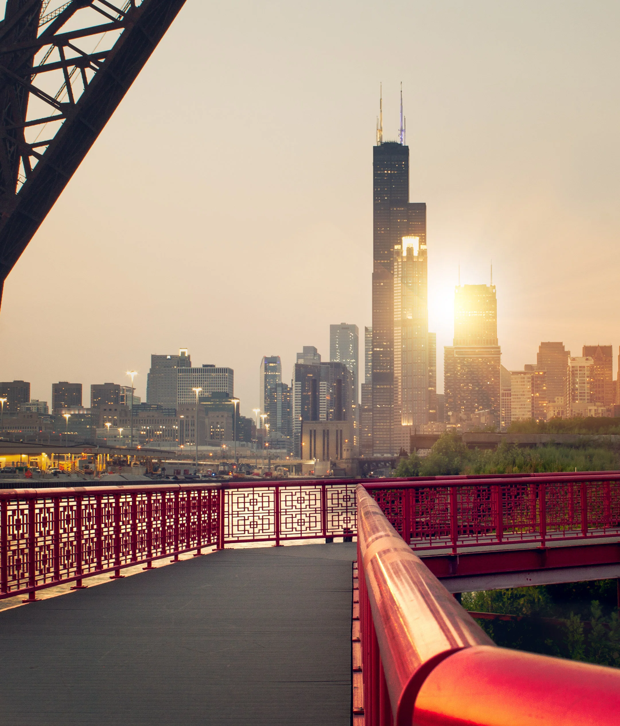
18th STREET BRIDGE
Another spectacular city skyline view is on the 18th Street Bridge, located just above Ping Tom Memorial Park. Point the camera up the South Branch of the Chicago River and behold the Windy City in all its glory.
This is an especially great spot for nightscape photography.
Fun Fact: With a 1967 construction date, the 18th Street Bridge is one of the youngest in all of Chicago.
Getting There: Red line trains to Roosevelt or green line to Cermak-McCormick Place

Chicago skyline as captured from the 18th street bridge in Chicago’s Chinatown
LINCOLN PARK BOARDWALK
The nature boardwalk at Lincoln Park makes for the perfect escape from the busy city streets. The pond is surrounded by prairie-style grass and is full of life with birds, frogs, and fish to name a few.
This is a great place to not only photograph the urban nature scene, but the John Hancock Building as well.
Pro Tip: Combine a visit here with North Ave Beach.
Fun Fact: The Nature Boardwalk acts as a living laboratory for the Urban Wildlife Institute in Chicago as they test new techniques to resolve human-wildlife conflict.
Getting There: Red, brown, or purple express line trains to Fullerton

Lincoln Park, Chicago
200 NORTH CLARK
In a massive city full of high rises, this is the place where you can see straight to the horizon and it feels as though the trains below are riding off into the sunset.
The reflective siding on the garage adds to the unique perspective and helps to create some stunning imagery.
Fun Fact: In 2016, the “L” train had 1,492 cars transporting passengers between 145 stations.
Getting There: Blue, green, pink, orange, brown, and purple express lines to Clark/Lake

The view from the parking garage at 200 N. Clark St. in downtown Chicago
WABASH ARTS CORRIDOR
Commonly referred to as the “living urban canvas” because new pieces are being added on an annual basis, the Wabash Arts Corridor is a unique collection of colorful murals.
Stretching from as far north as Polk and as far south as Roosevelt, this is the perfect place to wander around with your camera. Be sure to check the website for more information, including a walking map of each masterpiece.
One of the most popular works is the Moose Bubblegum Bubble by artist Jacob Watts.
Pro-Tip: Start on the southern edge at Roosevelt and make your way north back into the city’s downtown loop.
Fun Fact: The Wabash Arts Corridor was founded in 2013 by Columbia College and continues to grow into being one of the largest, unique, and accessible art projects in the country.
Getting There: Red, orange, and green line trains to Roosevelt & walk north
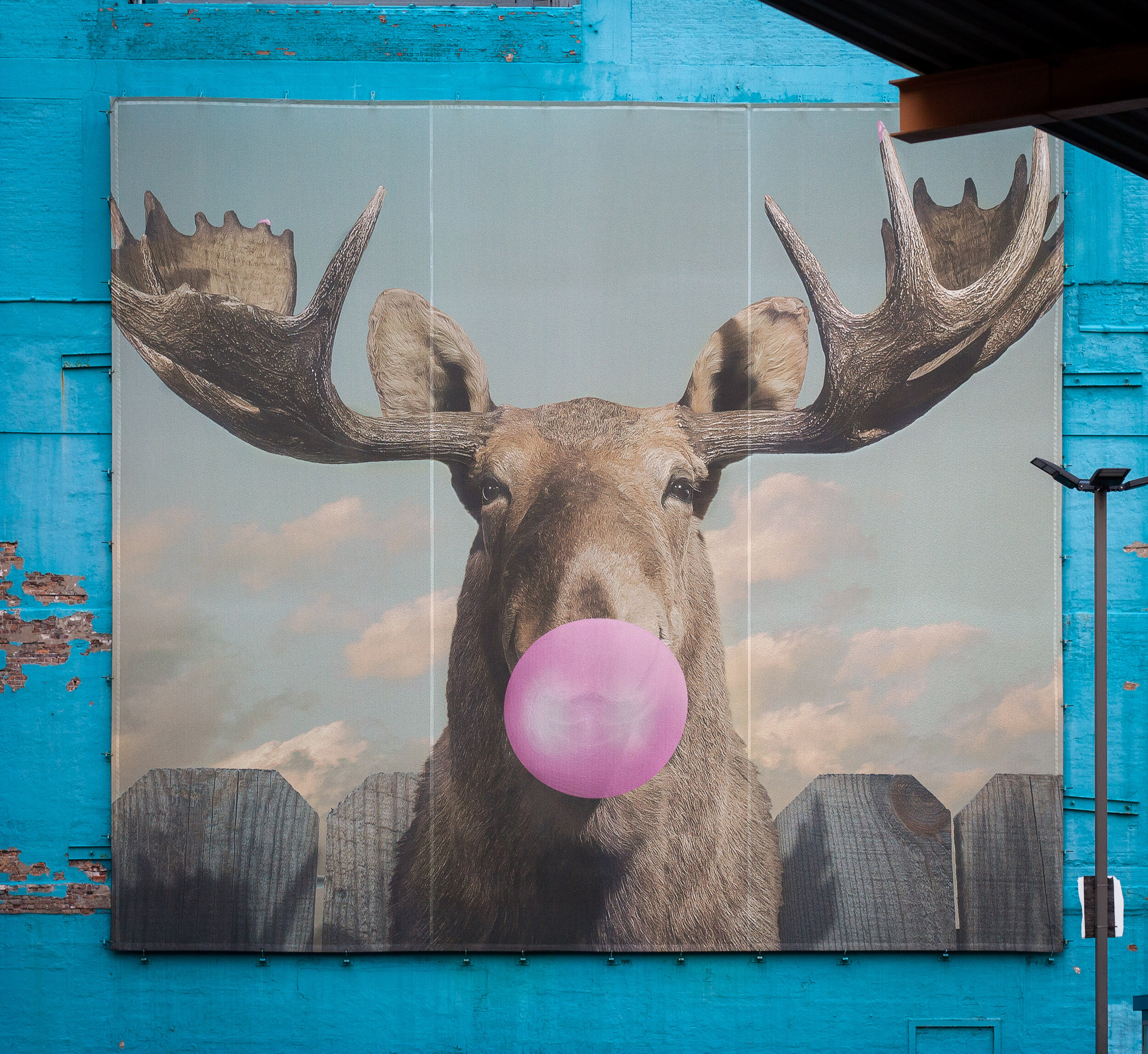
Moose Bubblegum Bubble mural by artist Jacob Watts
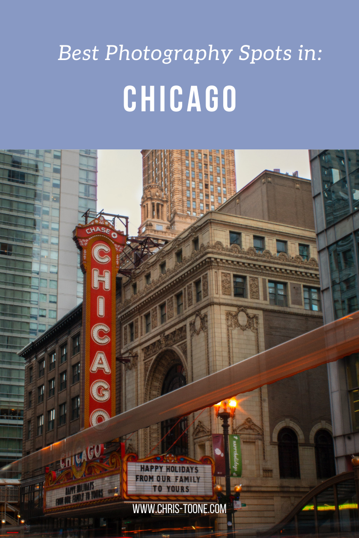
CHICAGO THEATER
Ok, you caught me. I can feel you rolling your eyes.
The vintage Chicago Theater sign isn’t exactly “off the beaten path”, but it does make for some pretty great long exposure shots and it’s a quick and easy stop on your tour of the city.
Fun Fact: The Chicago Theater was the first large movie palace in America and quickly became the prototype for all others. Constructed in a French Baroque style, look closely at the theater’s exterior to see if you can find the miniature Arc de Triomphe.
Getting There: Pink, green, brown, orange, and purple line express trains to State/Lake

Chicago Theater standing tall in the downtown traffic

The Chicago Theater shines bright in the snow
The truth is you just need to come here yourself and wander around. Each neighborhood, train line, and person has something unique to offer!
Stay safe & happy travels.
Enjoy what you read? Pin this post for later!


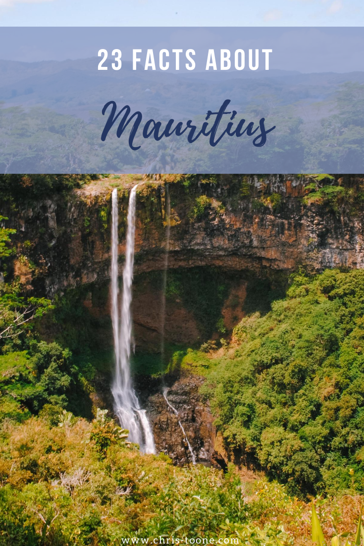
23 Facts About Mauritius: How much do you know about this tiny island nation?
From the Dodo bird inspiring a legendary children's novel to a multicolor landscape of volcanic dirt, how many of these facts do you know about the tiny island nation of Mauritius?
Mauritius is a country that has been on my mind a lot lately. As the world slips into the most politically and racially charged climate of my lifetime, I felt it important to highlight this tiny island nation because visiting here opened my eyes to a vital concept; acceptance.
This mindset is so ingrained in Mauritian way of life that the country is often referred to as a model for religious tolerance.
I’ll be the first to admit that as a 19-year-old traveling to this small slice of paradise off the coast of Madagascar with Semester at Sea, I knew next to nothing about the place.
So, other than what I just told you about their peaceful way of life, what about you? How much do you know about Mauritius?
Here are 23 facts to help paint a picture of what this country is all about; a beautiful picture at that!
1. The entire island of Mauritius is just 2040 square-kilometres
This makes it the world’s 181st largest nation in the world. The country is 45km wide and 65km long (CIA World Fact Book).
2. Mauritius is home to the Seven Colors of Earth
A popular tourist destination in Chamarel, these dunes of dirt contain a mix of colors that can be traced back to several volcanic eruptions, each that cooled at their own rate.

Seven Colors of the Earth | Mauritius
3. Three countries had control of the island prior to independence
The Netherlands ruled the land from 1638-1710 followed by France from 1715-1810. Surprise, surprise, in came the British in 1810 to take over and they remained in control of Mauritius until 1968.
4. More than 1.2 million people call this tiny nation home
This leads to a high population density. So high in fact that Mauritius has the highest of such in all of Africa.
5. Mauritius is the only African nation with Hinduism as the dominant religion
The country is 26.3% Roman Catholic, 17.3% Muslim, and 48.5% Hindu.
6. English and French are the most popular languages
You won’t find an official language for the country, but plenty of local Mauritians speak a form of Creole.
7. Mauritius’ flag is made up of four “bands”
Red represents the bloodshed for abolishing slavery and obtaining independence, blue for the vast Indian Ocean, yellow for the bright and shining future that lay ahead, while green symbolizes the lush green vegetation found throughout the island.
8. Mauritius was one of four countries around the world that were NOT engaged in domestic or international conflicts in 2017
Peace, tolerance and acceptance. It’s a concoction that works.
9. Even Mark Twain was rendered speechless by the island’s beauty
“Mauritius was made first and then heaven, and heaven was copied after Mauritius.”

Chamarel Falls, Mauritius
10. The Dodo Bird reigns supreme
Well… not really. The exotic flightless bird is now extinct, but Mauritius was the only known habitat. Due to the island’s lack of predators, the bird eventually lost it’s ability to fly.
11. Mauritius is a proud possessor of the UN Development Programs highest Human Development Index in all of Africa
Between 1990 and 2018, the country’s Human Development Index (HDI) increased from 0.620 to 0.796. The country is currently ranked 66th in the entire world and highest amongst the African continent.
12. More than 1.36 million visitors step foot onto the island each year
This figure significantly outnumbers the local Mauritian population.
13. Mauritius is a volcanic island that first rose 8 million years ago
14. The country does not maintain a standing army
Starting the see the peaceful mindset theme?
15. Port Louis is home to 40% of the population
This capital city was established back in 1736 by the French East Indian Company.

Port Louis, Mauritius
16. It’s widely believed that a stuffed Dodo Bird at the Oxford University Museum of Natural History inspired Lewis Carroll to write Alice in Wonderland
Thank you, Dodo bird.
17. Sugarcane is grown on around 90% of cultivated land in Mauritius
Other major land use includes tea, corn, potatoes, bananas, cattle and goats.
18. Black River Gorges National Park is home to one of the world’s rarest birds
Bird watchers worldwide flock here for a chance to spot the Mauritian Pink Pigeon.

Black River Gorge from above | Mauritius
19. The La Vanille Nature Park boasts an expansive collection of captive-bred giant Aldabra tortoises
The numbers stretch into the thousands and it’s a popular stopping point amongst visitors.

Giant Tortoise | Mauritius
20. Local cuisine is a tasty blend of Creole, Indian, Chinese, and French
Let your imagination (and taste buds) run wild.
21. The Grand Bassin Lake, or Ganga Talao, is Mauritius’ most sacred pilgrimage site for Hindus
A statue of Shiva lives along the lake and Hindus travel here annually to pay their respects.

Grand Bassin Lake, Mauritius
22. Sir Seewoosagur Ramgoolam Botanical Garden is the oldest in the Southern Hemisphere
23. Mauritius has received the World’s Leading Island Destination award not one, not two, but THREE times in the past decade
Between the exotic wildlife, lush mountains, and stunning beaches, it’s actually a mystery as to why they haven’t won it more.
Grand Baie, Mauritius
Ready to plan your trip?
Check out these hand-picked tours!
Enjoy what you read? Pin it for later!


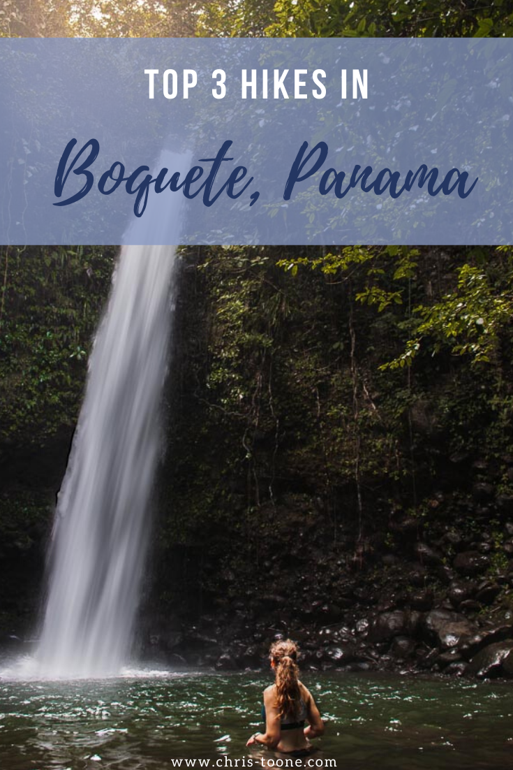
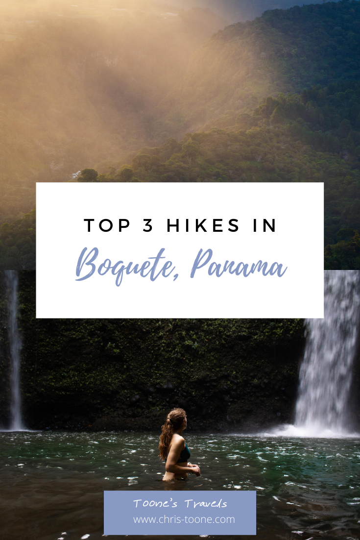
Top 3 hikes in Boquete, Panama
Drive 480km west of Panama City, Panama and the urban metropolis quickly yields way to a seemingly endless supply of rolling mountains and verdant jungle, eventually leading to an oasis named Boquete. Here are the top 3 hikes when visiting Boquete, Panama!

Drive 480km west of Panama City, Panama and the urban metropolis quickly yields way to a seemingly endless supply of rolling mountains and verdant jungle, eventually leading to an oasis named Boquete.
This mountainous town is nestled within a small valley of the Chiriqui Province and is widely known for being the home of the world’s best coffee. Despite this claim to fame, nature lovers from around the world flock here explore the seemingly endless supply of trails and untouched nature.
Although slightly overrun with ex-pats in recent years, Boquete still offers visitors a calming escape, whether sipping a cup of coffee in the foothills or roaming the numerous dirt paths that wind through the jungle.
My time in Boquete was spent hiking by day and enjoying the rolling thunderstorms as the made way for starry skies at night. To be honest, it was my favorite part of my 8-day trip to Panama and I can’t wait to get back!
Here are the top 3 hikes, plus a few others, for your trip to Boquete, Panama!
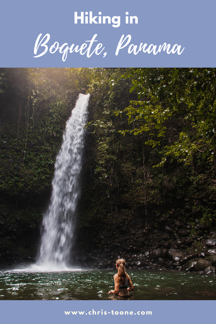
PIPELINE TRAIL
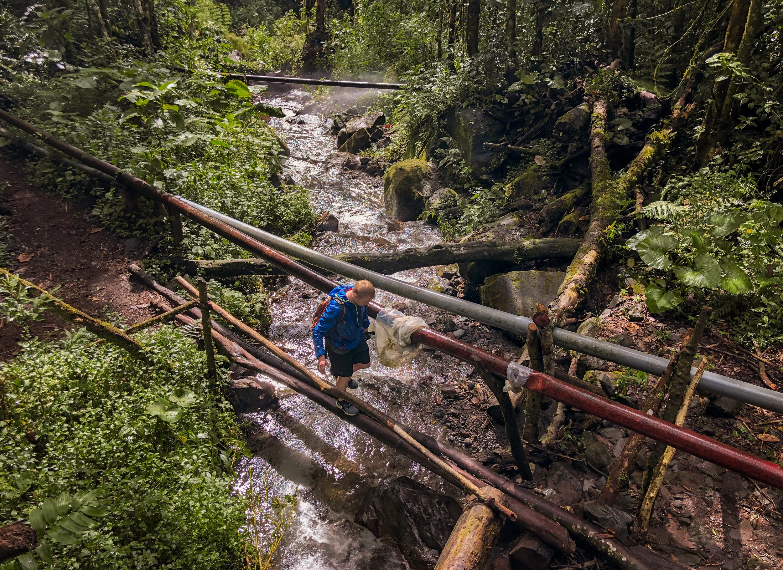
The Pipeline Trail in Boquete is aptly named because, well, it follows a pipeline along the river before culminating at a cascading waterfall. It’s one of the more popular trails in the area so the earlier you can go, the better.
Pipeline Trail | Boquete, Panama
What to Expect
The hike itself is relatively flat the entire way, making it easy to be on the lookout for wildlife. AllTrails has it listed as moderate, although I’d say it was certainly a family-friendly jaunt through the jungle.
There were a few spots that may be more difficult for those with limited mobility.
Local villagers regulate the Pipeline Trail. Don’t be surprised when someone appears and asks you to sign in and for 5 USD per person. It’s completely legitimate. Just don’t forget to mark yourself as “returned” on your way back to town!
After paying, we followed the trail as it quickly entered the dense Panamanian jungle. We were on high alert for snakes, howler monkeys, and more, although we had no such luck.
The Pipeline Trail is also widely known as a prime viewing spot for the elusive Quetzal, Panama’s most popular bird.

The Pipeline Trail as it enters the dense jungle in Boquete, Panama
Along the trail, we stumbled upon a 1,000-year-old tree. It stood majestically along the left side of the trail, subtly marked and easy to miss if we hadn't been in search of a convenient spot for a water break.
As we continued on and the dense jungle gave way to a towering canyon, the end was near. In the distance, we could begin to see the waterfall as it cascaded down from high above.
The slow-moving water provided a mist and a refreshing hangout spot to cool off from the humidity we had endured throughout the hike.
An hour and several pictures later, it was time to head back the exact same we had arrived, sign-out, and drive back to town.
When I first arrived in Boquete, I was a bit nervous. I have plenty of experience hiking in the desert and mountains, but very little within the jungle. I found the Pipeline Trail to be a great introductory hike to the region and it gave me the spark of confidence I needed to explore elsewhere!

The 1,000+ year old tree located along the Pipeline Trail in Boquete, Panama
The Facts
Elevation Gain: 1,528 feet
Distance: 3.8 miles out and back
Time: Estimated 2-3 hours depending on pace
Cost: 5 USD per person
Wildlife Viewing: Quetzal birds, snakes, howler monkeys
Getting There
From Boquete, head towards Los Naranjos and follow signs to Bajo Mono. Eventually the road will lead to a sign post that says PIPELINE. Park there and walk up the gravel road. You’ll know that you are in the correct place when you spot a hut to the left. That’s where the trail fee will need to be paid.
CHOCLON WATERFALL
Choclon Waterfall is a lesser-known trail located 40 minutes south of Boquete where twin waterfalls fill a secluded swimming hole at the end of a small gorge.
The path through the jungle is not regularly maintained nor is it distinctly marked, but if you know where you’re going it’s a simple hike.

Swimming at Choclon Waterfall in Boquete, Panama
What to Expect
I originally stumbled upon a picture of Choclon Waterfall while planning my trip down to Panama and immediately decided that it should be added to the itinerary. There was only one problem: Nothing I read told me where to find the trailhead.
Long story short, I was eventually able to track down GPS coordinates to the starting point, marked only by a closed gate and a small path through the barbed wire fencing.
We started the hike by sauntering across an open field before quickly descending to the jungle trail that led to a junction. After much deliberation, Heather and I realized that we had to go up and over a small gate rather than continue following the open trail.
View from the start of the hike before descending into the jungle
After the gate, the path is relatively short and easy to navigate. There were a couple of sections that rain had washed out, so be sure to watch your footing as you hug the wall of the gorge and use the ropes for provided support when available. They’re there for a reason!
A short through the overgrown brush and we had reached the river. Although we waded across the water, take a left instead and head upstream.
We were soon greeted by a magical amphitheater of hanging vines, beautiful waterfalls, and our very own private swimming hole.
We shed our clothes and jumped in as the soft sunlight shone through the canopy above and illuminated the refreshing blue water. It was the perfect ending to a full day of adventure!
To read more about the adventure, visit this post: Chasing Choclon Waterfall

Swimming at Choclon Waterfall in Boquete, Panama
The Facts
Due to the lack of information surrounding Choclon Waterfall, here’s what I can offer:
Elevation Gain: Unknown, but remember that it is a gorge trail, so the ascent will occur on the way back to the trailhead
Distance: Unknown
Time: 30min from trailhead
Cost: Free
Wildlife Viewing: Poison dart frogs, various birds and snakes
Getting There
The easiest way to find the trailhead is by tracking mileage.
From Boquete, travel south via Highway 41. As you pass by Faro Panama (the giant lighthouse), start paying attention to the odometer. Approximately 7.2km later, there will be a sharp right turn. If you reach the town of Nuevo Dolega, then you’ve gone too far by 4km.
Follow the road straight. Eventually you’ll reach a junction where the road swings left. On the lefthand side will be a closed gate with a small opening in the barbed wire fencing. This is the trailhead!
LA PEIDEA DE LINO
A short but steep hike, La Piedra de Lino is the equivalent of an endless stair-stepper machine. If you can grin through the pain, the reward at the top is worth it as the trail offers the best views over the Boquete valley below.
Climbing the steep terrain of the La Piedra de Lino hike in Boquete, Panama
What to Expect
La Piedra de Lino directly translates as “the rock of Lino,” a small community 4km from Boquete. The trailhead is clearly marked, making it one of the easier hikes in the area to find.
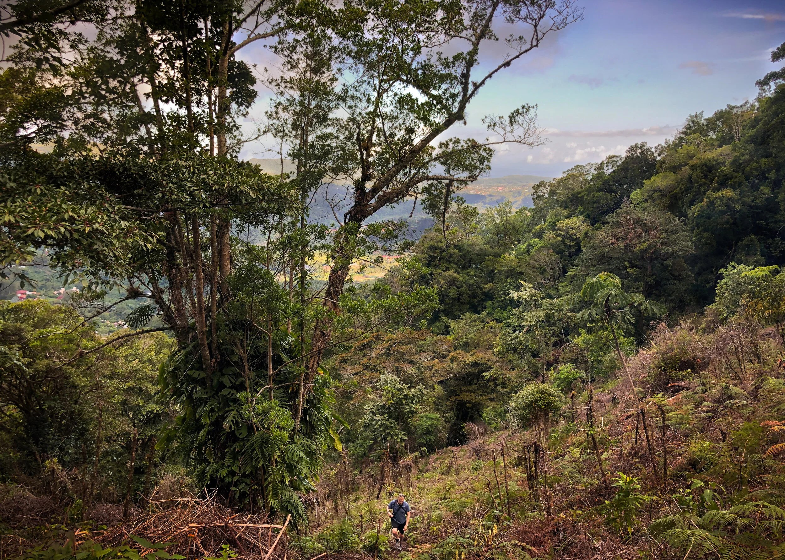
The steep path started right away as we made our way up the driveways and we were instantly grateful that we had chosen to give ourselves an afternoon full of rest and relaxation around town before tackling this hike.
Once we entered the jungle we passed by an abandoned house before continuing up, regularly turning around to “enjoy the view” because neither of us wanted to admit how out of shape the terrain made us feel.
Our trip to Panama coincided with the start of the rainy season, which meant that the trail was slippery and washed out in some areas. We hiked in running shoes, but in hindsight would have been much better off bringing a shoe with better tread and a pair of walking poles.
The hike continued to be one recurring theme: up, up, up.
Once at the top we traversed the ridge through a small shaded area, stopping only to graciously allow a snake to cross the path in front of us.

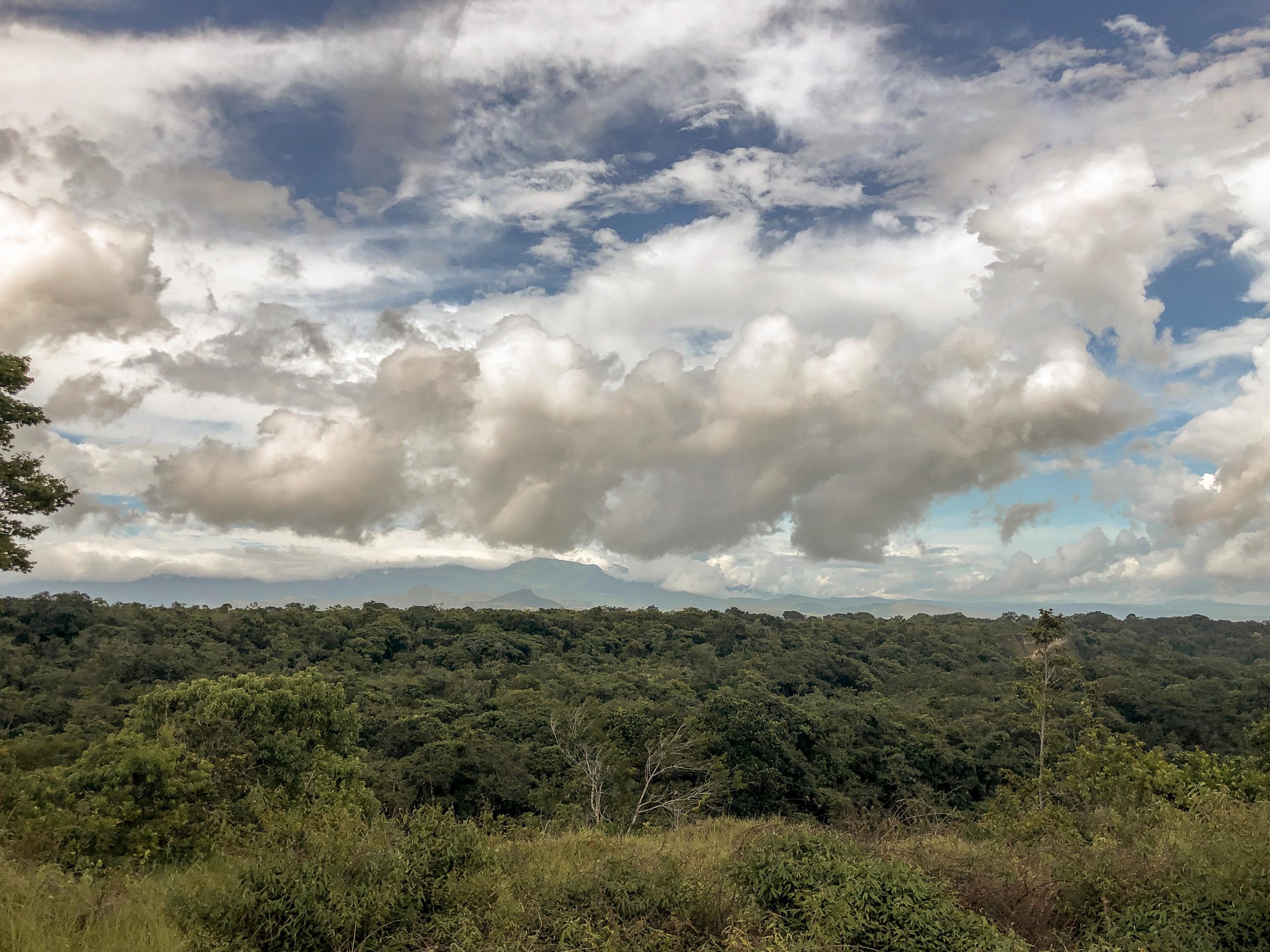
Clouds moving through the jungle at sunset as seen from the top of La Peidra de Lino
All of the pain and suffering immediately subsided when at the clearing we were greeted to the most spectacular view I witnessed during my time in Panama. To the right were soft clouds moving quickly through the mountains while to the left was a picture-perfect view of Boquete.
Needless to say, it was worth the effort and timing it with the sunset was a bonus (just remember to pack a headlamp for the way down)!
Looking over Boquete, Panama from the top of the La Piedra de Lino trail
The Facts
Elevation Gain: 322m
Distance: 2.7km
Time: 40min, but varies greatly based upon fitness level
Cost: Free
Wildlife Viewing: Birds and snakes
How to Get There
Have a GPS available? Simply search for Hostal Casa Pedro and this will lead you straight to the trailhead. If you don’t see a sign that reads “Sendero La Piedra de Lino” then you’re in the wrong place!
If this luxury isn’t available to you, simply head north on Via Boquete and turn right at Avenue Buenos Aires. This road takes you straight to the trail and all you’ll need to do is be on the lookout for the white sign.
If you reach IL Pianista, then you’ve gone too far.
BONUS HIKES
El Pianista
A 3-4 hour out and back trail with 2,000 meters of elevation gain, El Pianista leads you through a moody cloud forest that’s dripping with life before arriving that the summit.
The trail made headlines around the world when two dutch girls in their early 20’s went missing back in 2014. Although officially ruled a hiking accident, many locals believe that Lisanne and Kris were met by foul play in the jungle.
The Lost Waterfalls
One of the more popular hikes in Boquete, The Lost Waterfalls trail winds through the dense jungle, over a suspension bridge, and culminates at 3 stunningly beautiful waterfalls.
Sendero Los Quetzales
Sendero Los Quetzales is a 15.6 mile trail that connects Boquete to Cerro Punta through the jungle. It’s common to hike sections of the path in search of the elusive Quetzal bird.
Volcan Baru
It’s often suggested to begin this 15 mile trail at midnight in order to reach the summit of the tallest mountain in Panama by sunrise. On a clear day, it’s possible to see both the Caribbean Sea and the Pacific Ocean from the top.
Whether you prefer sauntering along in search of diverse wildlife or grinding out elevation gains to the top of a peak, Boquete is truly a mecca for nature lovers and was hands down my favorite stop during our Panamanian adventure. Next time, I plan on spending far longer than 2 days hiking around the town!
Have you ever been to Boquete before? Have a favorite hike abroad? Let me know in the comments below!
Thanks for reading and as always, stay safe & happy travels.
It’s time for an upgrade! Here’s my favorite hiking gear:
Pin this post for later!


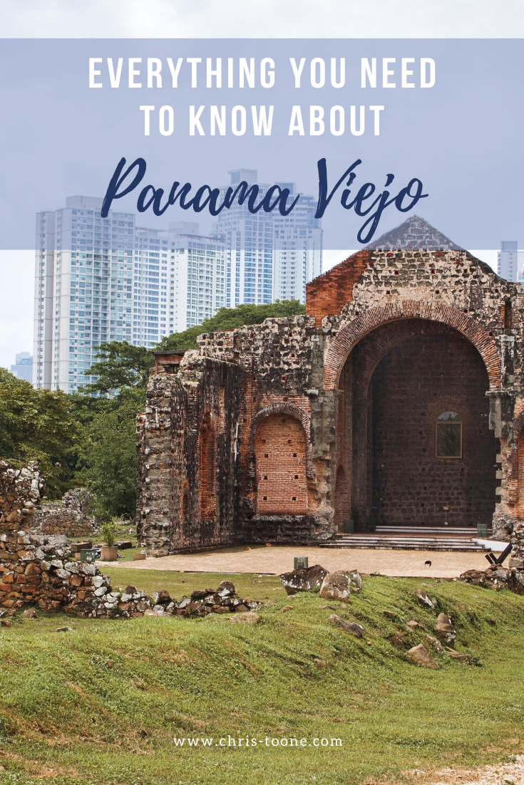
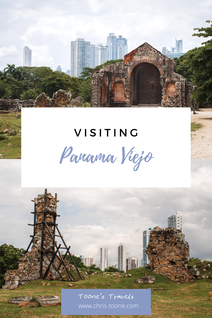
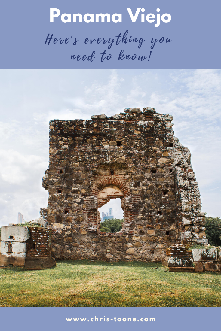
Visiting Panama Viejo: Everything you need to know before you go
Panama Viejo was the first European city built along the Pacific Ocean in the Americas and was established in 1519 by Pedro Arias Davila. Its prime location quickly created a trading metropolis, but that led to attacks from pirates that ultimately destroyed the city. Today, Panama Viejo as a UNESCO World Heritage Site. Here's everything you need to know!

Plan a trip to Panama City, Panama and I’m confident you will quickly discover Casco Viejo, which directly translates as “old town”.
The truth is, although the neighborhood is historical and full of colonial-era architecture, it’s not the original Panama City settlement.
Travel 8km northeast of Casco Viejo and you’ll find Panama Viejo, a sprawling 28 acre space full of crumbling ruins that offers visitors insight into the very first colonial outpost in all of Panama.
Here’s everything you need to know before your visit!
THE HISTORY
The first European city built along the Pacific Ocean in the Americas, Panama Viejo, was established in 1519 by Pedro Arias Davila during the Spanish Colonial era.
Situated along a shallow cove, its prime location quickly created a trading metropolis, most notably of gold and silver. Although the settlement was prospering, the ships that transported treasures back to Spain quickly caught the eye of pirates.
In 1671, the attacks came ashore as the famous pirate, Captain Henry Morgan, went for the jugular, ransacking and pillaging Panama Viejo to the point of destruction.
When it was all said and done, thousands of people had perished and the city was left in ruins.
Rather than re-build, the survivors moved and established a new town in what is presently known as Casco Viejo (completed in 1673).
The peninsula in which the new city was settled upon served as a natural geographic defense system while walls, which are still standing to this day, were built as reinforcements.
Fast forward to 1997, Panama Viejo was established as a UNESCO World Heritage Site and is now the most well-funded archaeological site in the entire country.

Ruins at the Panama Viejo UNESCO World Heritage Site in Panama City, Panama
GETTING THERE
Panama Viejo is located on the northern end of the city, 8km away from Casco Viejo.
Parking is limited so it’s best to arrive via taxi or Uber, otherwise you can expect to have to park a good distance away and hoof it to the entrance gate.
If arriving by bus, take the following routes:
Panama Viejo-Via Israel-Albrook (departs from Balboa and from Albrook)
Old Panama-Seafood Market (Exits the Seafood Market)
Panama Viejo-Cinta Costera (Departs from Albrook)
Albrook-Via Porras-Cincuentenario (Departs from Albrook and from May 5)
Address: Panama Viejo, Vía Cincuentenario, Panamá, Panama
Phone: +507 226-8915
Hours: 8am - 5pm, closed on Mondays
COST
General entrance to the Panama Viejo complex includes access to the walking path through the archaeological park, museum, and viewing platform from the Cathedral tower.
National adults: $10.00
Foreign adults: $15.00
Children: $2.00
PACK ACCORDINGLY
Water Bottle - There is a cafe near the Cathedral tower, but bring your own bottle and save some money.
Daypack - The best way to explore the ruins is to walk amongst them, so it’s important to have a convenient way to carry your camera, water bottle, sunscreen, etc.
Rain jacket - Rainy season hits Panama between the months of April and December. I was caught huddling under a tree for shelter more than once during my visit. Don’t be like me; go prepared.
Comfortable Shoes - It’s a 15 minute walk from the ticket booth to the heart of the ruins, so make sure to dress accordingly (a free shuttling service is provided for those in need).
WHAT TO EXPECT
First things first: Visit the museum on the grounds to get a better understanding of all that Panama Viejo represents.
The exhibits trace history from pre-colonial times through the era of Spanish conquistadors as well as original maps of the settlement and history of pirate activity in the area.
At the very least, it serves a great and informative shelter from the rain!
Once you feel your knowledge is sufficient, then it’s to time to wander amongst the ruins (Lonely Planet outlines a great self-guided tour).

Ruins of the Iglesia y Convento de San Francisco looking towards a modern Panama City, Panama
There are set pathways throughout the grounds, but it’s completely acceptable to get up close and personal as long as a sense of respect is maintained. Remember: You don’t want to be the tourist that’s caught damaging a World Heritage Site!
The archaeological complex was fascinating in its own right, but what struck me the most was that the ruins were situated next to a major highway with downtown Panama City as a backdrop, skyscrapers and all.
The contrast between old and new was stark and certainly thought-provoking. It really gave a whole new perspective as to the growth that the area has seen over the centuries, so don’t forget to look beyond what first meets your eyes. See the whole picture and take a moment to process the spectrum of history that stands before you.
Iglesia y Convento de la Concepción is one of the most well-preserved buildings in the complex while the tower of the Catedral de Nuestra Señora de la Asunción allows visitors the chance climb the stairs to the top and look out over the expansive ruins.
The Iglesia y Convento de la Concepción standing tall at Panama Viejo
Other buildings of note include the Casa Reales (Royal Houses) where the center of the town’s power resided, Cabildo de la Ciudad (City Hall) and Casa Alarcón (Panama Viejo’s largest known private residence).
Although visitors flock to Panama City to learn about the canal and roam the colonial quarters of Casco Viejo, a visit to Panama Viejo is a must-do in order to grasp the deep history of this fascinating place. It’s worth the 15 USD entrance fee!
Have you been to Panama City before? What were your thoughts? Let me know in the comments below and until next time, stay safe & happy travels!
Book a tour with Get Your Guide and unlock the beauty of Panama City, Panama!
Sharing is caring… pin this post!

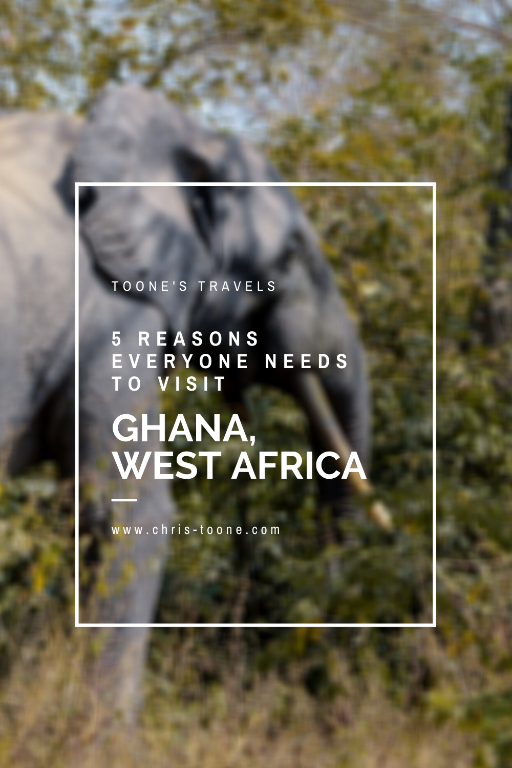
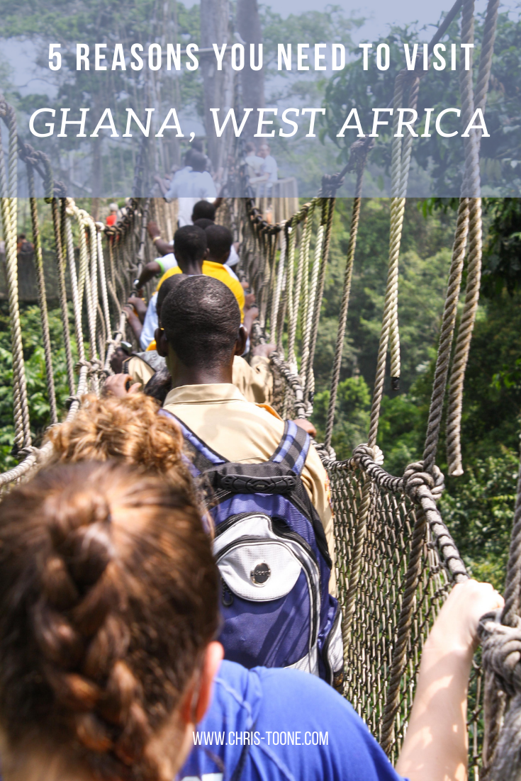
5 reasons why you should visit Ghana at least once in your lifetime
Although widely considered to be "Africa for beginners," Ghana is often overlooked by travelers. Maybe people don't want to walk with elephants or relax on unspoiled beaches. Whatever your reasons may be, here are 5 as to why everyone should visit Ghana at least once in their lifetime.

Please note: This post was updated as of December 2023
Although widely considered to be "Africa for beginners," Ghana is often overlooked by travelers.
I suppose, in a way, it can be quite overwhelming with too much nature to explore, too many foods to choose from, or a local culture too vibrant to step into.
Sounds terrible, right?
Here are 5 reasons that you should make time to visit Ghana at least once in your lifetime!
1. DIVERSE WILDLIFE
A one hour flight north of Accra to Tamale gives access to Mole National Park, the epicenter of Ghana’s wildlife.
Mole was the first National Park established throughout the country and covers 4,577 square kilometers of burnt orange savannah.
Once inside the park, visitors are transported into a world full of wildlife, including antelopes, bushbucks, monkeys, rare birds (most notably the white-backed vulture), and even leopards, although extremely rare.
It’s not uncommon to be wandering the grounds of the Mole Motel, only to stumble upon a family of warthogs grazing in the grass.
Don’t get distracted for too long though, as the pesky baboons aren’t shy about rummaging through your belongings. During my first visit, I zoned out at breakfast only to realize a baboon had jumped onto the table, stolen the toast and butter, and was cheekily consuming it 10 yards away.
What’s so special about Mole National Park, you ask? The elephants.
Yes, I failed to mention that it’s an elephant hot spot and a prime place for viewing these magnificent mammals between December and April.

Due to the lack of predators within the park’s boundaries, safaris can be done on foot when accompanied by an armed guard. This means that visitors can come within mere feet as elephants graze the savannah.
In total, Mole National Park encompasses 90 different species of mammals, 334 of birds, 33 of reptiles, and approximately 120 of butterflies.
It was a surreal experience, to say the least.
Other places of note include the Boabeng Fiema Monkey Sanctuary in Nkoranza and the remote Wechiau Hippo Sanctuary, tucked away in the Upper West Region along the border with Burkina Faso
Looking for a little more luxury? Check out Mole National Park’s Zaina Lodge. This all-inclusive resort comes complete with an infinity pool, fine dining, and games drives.

Walking with elephants at Mole National Park
2. VIBRANT CULTURE
Thailand might be known as the “land of smiles,” but I’m willing to cast my vote for Ghana to claim the title.
Upon landing in Accra, visitors will notice the positive vibes that are emitted from the locals as they smile and greet everyone that passes by. Don’t be surprised if you make a few friends on the streets and the two of you are suddenly chatting as childhood best friends do. It’s completely normal.
Ghanaians aren’t afraid to express themselves through any means and the perfect place to experience it all at once is Makola Market. Wander through the narrow paths as sellers shout their prices, negotiations become animated, and people move to the beat of the music that fills the air.
It’s no wonder everyone is so happy. In a sea of dust and smog, Ghana’s arts shine bright.
For proof, the stalls full of kente cloth goods at the Center for National Culture.
This vibrant cloth was once sacred amongst the Akan people, reserved for Kings and Queens to wear in times of great importance. Although it’s turned mainstream for the sake of souvenirs in Accra, the royal culture is alive and well in villages throughout the city.
Side note: When visiting a village it’s customary to present the elders with a bottle of schnapps. During one of my visits with Aya, we abided by this custom and he, in turn, presented us with a live goat. I’d like to think that he’s still happily roaming the fields of central Ghana where we set him free.
Whether dancing the night away with locals on the famed Labadi Beach or wandering the halls of the Artists Alliance Gallery in Accra, even the most introverted people can’t resist the vibrant culture in Ghana (I can personally attest).

Traditional drumming & dance performance in Senase, Ghana
3. DELICIOUS FOOD SCENE
Whether in search of traditional fare or cuisine from around the world, Ghana has got you covered.
Dive into a bowl of fufu, a ball of pounded cassava served with stew, or jollof rice, a mixture of tomato paste and rice that packs a punch with a pinch of habanero pepper.
Ghanaians are passionate about their jollof. So much so that a seemingly endless online debate has been taking place for years with Nigerians as to whose jollof rice is the best. For neutrality’s sake, I’m going to keep my mouth shut (but definitely have some while in Ghana, if you catch my drift).
Another personal favorite is the mouth-watering bofrot, the African version of a donut. It’s easy to find a street vendor selling this traditional fried snack on most corners, serving as a quick, easy, and cheap breakfast.
As vast as the traditional foods might be, the global food scene shines bright in the capital city of Accra.
Visit Burger & Relish in the lively neighborhood of Osu for arguably the country’s best burger or enjoy an evening at Santoku for an innovative Japanese experience.
Whatever your food preference may be, you can find it in Ghana.

Traditional Ghanaian fufu
4. DEEP HISTORY
Ghana’s vibrant culture becomes next-level when considering the dark and gut-wrenching past.
Today, 40 castles that formerly housed slaves before loading them onto ships bound for the New World dot the coastline. Of the 11 million to cross the Atlantic, most were taken to South America or the Caribbean but it is thought that around 500,000 Ghanaians disembarked in the United States.
Cape Coast Castle is the most popular of former slave sites to explore and provides visitors the opportunity to experience first-hand the suffocating, dark dungeons that housed 1,000 males and 500 females with minimal food and no sewage available.
The most chilling part of the experience is by far walking through the infamous “Door of No Return,” where slaves once took their final steps in their homeland before a life of labor elsewhere became the reality. That’s if they were fortunate enough to survive the ocean crossing.
It was on March 6th in 1957 when the resiliency of Ghanaian’s paid off and the country became the first sub-Saharan nation to gain independence.
Needless to say, there’s a long and storied history here and it begs to be explored. What better way to do so than to do it first-hand?

Cape Coast Castle looking towards the “Door of No Return”
5. UNSPOILED NATURE
A 4.5-hour drive east of Accra lies Wli Falls, conveniently situated along the border with Togo. Cascading into a pool from 80 meters (262 feet) above, it’s West Africa’s largest waterfall and just a scratch on the surface of all that Ghana has to offer.
Hikers can climb to the top of Mount Afadjato (885 meters/ 2,903 feet) the highest peak in the country, while beachgoers can head south to Ada Foah and stay at the off-the-beaten-path Maranatha Beach Camp for some much-needed relaxation and fun in the sun.
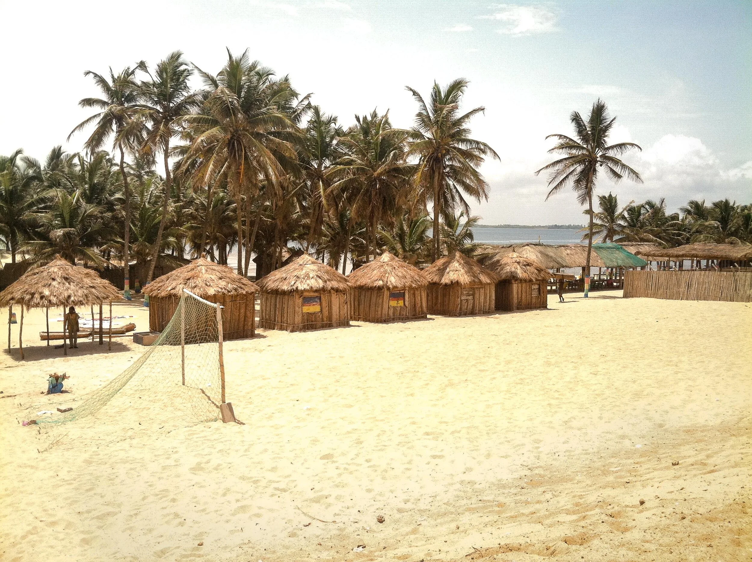
Maranatha Beach Camp in Ada Foah, Ghana
If mountains and beaches don’t do it for you, then how about rainforest hiking?
Kakum National Park is located a short drive north of Cape Coast, Ghana and encompasses 360 square kilometers of the country’s rapidly receding vegetation.
It’s also the home to the famed canopy walk where visitors saunter between the treetops on a precariously placed piece of wood (it’s completely safe, I swear).
Forest elephants and bongo antelopes, both endangered, call this park home while guided hikes from the visitors center help hikers spot birds and butterflies.
Hiking, birdwatching, swimming, sunbathing; Ghana has it all.

Canopy walkway at Kakum National Park
Hopefully, by now you’re a bit better acquainted with all the beauty, both natural and cultural, that this West African nation holds.
If not, here’s the moral of the story: take a trip to Ghana. Explore it, live it, breathe it and enjoy the ride!
Have you ever been to Ghana before? What was your favorite part? Let me know in the comments below!
As always, stay safe & happy travels.
Pin this post!

Staying at the Maranatha Beach Camp: Where the river meets the sea
Traveling through Ghana? Don't miss out on staying at the Marantha Beach Camp. Complete with thatched huts and a surplus of coconuts along a blissful stretch of sand, you'll fall asleep to the sound of the crashing waves after a day full of relaxation or adventure - whatever you choose!
Please note: This post is updated as of December 2023
Have you ever found yourself scrolling through Instagram and stumbling upon someone else’s picture-perfect beach vacation, only to look up from your phone and realize it’s time to get back to work?
Me, too.
Luckily for all of the budget travelers in the world, there’s a magical place just outside of Accra, Ghana where the Volta River flows out to the Gulf of Guinea and palm trees provide shade to the tiny thatched huts that dot the coastline.
Welcome to the Maranatha Beach Camp where, quite literally, the river meets the sea.
THE HISTORY
Maranatha Beach Camp was founded by Winfred Dzinado back in 2005 and started as a one-man operation with only a couple of huts on a strip of sand in Ada-Foah, Ghana. Since that time, it has expanded to 30 available bungalows.
His motivation stemmed from a perceived need for the education of children within his community. Families had been neglecting to send their children to school because of the distance or required financial commitment, both common problems throughout the country.
As Winfred continued his business, he began using the profits to fund affordable and convenient education, starting with the construction of one small classroom and thus establishing the Maranatha Community School.
Today, the school now holds classes for children from 4-15 years old and is partially Government supported while the beach camp’s profits continue to pay for building upkeep and a few teacher salaries.
Needless to say, you can feel good about where your money is going!

Maranatha Beach Camp as seen from the water
BOOKING
The beauty of the Maranatha Beach Camp is that you won’t find it on any booking site. Outside of reviews on TripAdvisor, there’s really not a whole lot of information out there, which only adds to the allure of this isolated oasis.
Don’t worry, I can see your confusion. If there’s no information available, then how does one book accommodation?
Send an e-mail request. Once a response is received, you’re good to go! That’s all it takes.
There is no online payment processing and no deposits necessary. Simply show up and pay on site in cash.
GETTING THERE
The first step in reaching the beach camp is to find your way to the small fishing town of Ada-Foah. This can be accomplished by either private taxi from Accra or using the public transportation system, commonly referred to as Tro-Tros (find the van heading to Ada-Foah from the Tudu Station in Accra).
After the 2 hour drive east from the capital, you can either hire a motorbike to Maranatha and walk the rest of the way through the town (the walk is across the sand, so it’s not ideal if you’re dragging large suitcases) or you can arrange to be picked up by boat (additional charge per person).
If opting for the latter, it’s best to arrange it through the beach camp prior to arrival in order to save money. Other people will offer their boat services once you arrive in Ada-Foah, but these will typically be a bit more expensive.

Arriving via fishing boat
THE ACCOMMODATION
It’s important to keep things in perspective when talking about what’s available. Maranatha Beach Camp is off the beaten track, comprised of thatched huts on the beach, and is relatively isolated meaning that electricity and running water are scarce.
Does that mean you should stay away? Absolutely not. It’s just important that you know what to expect before you show up with a mental image of a pristine beachfront cabana.
With that being said, I was pleasantly surprised with the overall quality and cleanliness. It’s clear that Winfred and his staff care deeply about what has been built and it shows in how they maintain and continuously improve their facilities!
Rooms (prices as of 2023):
It’s almost inconceivable how affordable room rates are, making it a great place to visit for any budget traveler. Here’s the gist:
Sand Floor Rooms: 60-100 GHC per night
Turtle Lodge Rooms (enclosed with solid floor): 100-200 GHC per night
VIP room with washroom: 250 GHC per night
Keep in mind that each hut is mere feet away from the water’s edge. There’s no such thing as a “good or bad location” here.
Facilities:
Communal vault toilets and bucket showers are available and cleaned daily. It’s not luxury by any means, but trust me when I say that guests have everything they need.
A small soccer pitch and volleyball court have been drawn out in the sand and there are plenty of games to play and hammocks to lounge in throughout the day.
Food and drinks are available by cash purchases at the restaurant/bar on site. Everything is sourced locally and is very affordable, so you won’t break the bank by eating 3 meals a day.

Beach huts dot the beach along the soccer pitch
WHAT TO EXPECT
Maranatha Beach Camp isn’t just a hangout for foreigners, but it’s a local hotspot as well! You’re just as likely to meet fellow travelers from around the world as you are to converse with people from the surrounding communities, especially on the weekends.
Upon arrival, you'll be offered the chance to tour the Maranatha Community School. Take it. It’s a great way to learn about the history of the operation and will shed new light on just what the beach camp means to the community.
The daytime atmosphere is laid back and friendly. Lounge in a hammock as local vendors pass through with fresh coconuts, start a game of volleyball, swim in the Volta River (much calmer than the Gulf of Guinea) or, if visiting on the weekend, dance the night away around the infamous beach bonfire.
It’s also possible to organize a boat tour around the Volta Estuary to places like Rum Island, where locally sourced sugar cane is turned into this satisfying spirit. The Volta River is an important part of Eastern Ghana, and spending some time cruising around is a great way to gain insight as to just how vital of a role it plays in sustaining life.
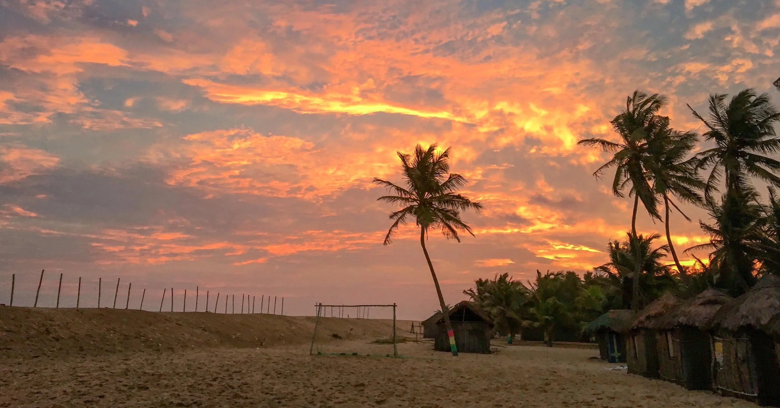
As the day ends, grab a cold beer while sunset illuminates the sky. One of my favorite things to do in the evenings is simply to sit on the beach and watch the twinkling lights of passing ships as they move across the horizon. My body may relax, but my mind never stops wandering!
Sunset over the Gulf of Guinea
IMPORTANT TIPS
Charge electronics ahead of time: With limited electricity, it’s important to make sure larger electronics you plan on using have full juice ahead of time (i.e. a camera). A portable power bank is a great item to pack for smaller gadgets!
Overestimate cash needed: Maranatha Beach Camp is a cash-only establishment. Normally this wouldn’t mean much except there are no ATMs available in the area. It’s important to bring enough money for accommodation, transportation, meal costs, extra boat tours, drinks at the bar, etc.
During one of my visits, I was forced to ask the tro-tro to stop at an ATM on the way back to Accra because I had no more cash in my pockets and wouldn’t have been able to pay for the ride!
Bring supplemental snacks: This is especially important if you are a vegan. Although food is fresh and available at the restaurant, it can be difficult to find something to fit that specific dietary need. Make sure to shop ahead of time as, like ATMs, there are no supermarkets to be found.
Plan on buying goods: Whether a bottle of local sugar cane rum or handmade jewelry from a vendor on the beach, plan on at least having the opportunity to purchase some sort of souvenir and factor that into your cash withdrawal.
WORTH IT?
Absolutely.
The friendly atmosphere is second to none and it’s a great opportunity to engage with the local community.
Most visitors spend 2-3 days here and leave feeling rested and relaxed, but if you’re in search of a longer escape then it may be worthwhile to learn about the community’s organized volunteer programs.
Either way, next time you find yourself in Ghana, make the effort to visit the Maranatha Beach Camp!
It’s certainly not the easiest of places to reach, but the most beautiful ones never are and I won’t soon forget this little slice of paradise.
So, are you ready to claim your very own beach bungalow and unwind for a few nights? I know I am!
Feel free to leave any questions in the comments below and I’ll do my best to answer them.
Until next time, stay safe & happy travels!
Enjoy what you read? Pin this post!


